Limi Valley Trek
On Request
19 Days / 18 Nights
Min. 4 / Max 12 Trekkers
Strenuous
Boutique Hotels & Mountain Lodges
Max 4900 Mt
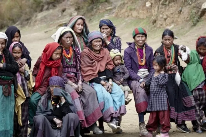
Witness the Vibrant Tibetan Culture and Lifestyle
Limi Valley Trek, a journey through one of Nepal’s most remote and culturally rich regions. Nestled in the western Himalayas, the Limi Valley offers an unparalleled opportunity to experience vibrant Tibetan culture and breathtaking landscapes. As you trek through this isolated paradise, you’ll follow ancient salt trading and pilgrimage routes that have connected Nepal and Tibet for centuries.
Your adventure takes you across the Nara Lagna Pass (4,620m) and the Nyalu La Pass (4,900m), offering spectacular panoramic views of the Himalayas. The rugged trails and high-altitude terrain make this a rewarding challenge for seasoned trekkers looking to explore off-the-beaten-path destinations. Along the way, you’ll traverse pristine valleys, cross glacial rivers, and marvel at towering snow-capped peaks.
One of the most exciting aspects of the Limi Valley Trek is its rich biodiversity. Keep your eyes open for elusive snow leopards, Himalayan blue sheep (bharal), musk deer, jackals, and Kiangs (Tibetan wild asses) roaming the high-altitude landscapes. The region’s untouched beauty and remote location provide a rare chance to witness these magnificent creatures in their natural habitat.
This 18-day trek (with 15 days of actual hiking) is moderate to strenuous, requiring several hours of trekking daily at altitudes above 3,000m. Proper acclimatization is key to ensuring a safe and enjoyable journey. That’s why our itinerary is designed with gradual altitude gain, ample rest days, and expert guidance from experienced trek leaders. The best time to embark on this trek is between May and October, when the weather is stable and the passes are free from heavy snow.
Beyond the adventure, this trek is also a cultural immersion into the traditions and spiritual life of the Limi Valley. Along the trail, you’ll visit ancient Buddhist monasteries, interact with welcoming locals, and witness age-old rituals that have remained unchanged for centuries. Highlights include exploring the stunning rock formations along the Karnali River, rejuvenating in the healing hot springs at Chugzur, and enjoying the serenity of monasteries that dot the landscape.
At Responsible Adventures, we prioritize sustainable tourism, cultural respect, and guest comfort. Our small-group approach ensures a personalized experience while supporting local communities. We arrange accommodations in carefully selected Deluxe Eco-lodges away from crowded routes, ensuring a tranquil and authentic trekking experience.
Join us on this extraordinary journey through the Limi Valley—a trek that combines adventure, culture, and breathtaking Himalayan landscapes. Book your trek today and experience Nepal in style!
Itinerary
Upon your arrival in Kathmandu, your trek leader will be at the airport to welcome you and assist with your transfer to the hotel. Expect a briefing from your trek leader, outlining the itinerary for the upcoming days.
After enjoying breakfast, it will be time for you to pack your belongings and check out from the hotel. In the morning, you will take a walking tour of some prominent landmarks in Kathmandu. The tour includes visiting the iconic Swayambhunath Stupa, known as the “Monkey Temple,” which offers magnificent city views. You will also explore the historic Kathmandu Durbar Square, a UNESCO World Heritage Site known for its ancient royal palaces, temples, and intricate woodwork.
Following the morning tour, you will have a lunch break in Thamel’s vibrant neighbourhood, known for its diverse dining options. Afterwards, you will be transferred to the domestic airport for your flight to Nepalgunj. Nepalgunj is a major city in western Nepal and serves as a gateway for various remote Himalayan regions, including the Limi Valley.
Please note that specific details and timings may vary depending on the tour operator and the itinerary you have chosen for your trip. It is advisable to check with your travel agency or tour organizer for the precise schedule and any updates.
Upon arrival in Simikot, after an early morning flight from Kathmandu, you will be greeted by the locals, who will offer you a traditional white silk scarf called Khata. This symbolic Tibetan ritual represents a warm and respectful welcome from the community.
Simikot, situated on a ridge overlooking the Humla Karnali River, is not only the district headquarters of Humla but also serves as a gateway to Mount Kailash and Western Tibet. The village has a charming appeal, characterized by a blend of Hindu and Tibetan cultures, offering endless opportunities for exploration.
At an elevation of 2900m, it is essential to be cautious of the effects of high altitude. Take it easy upon arrival, ensuring proper hydration and allowing time to acclimate as you leisurely explore the village.
Today’s trek begins with a short climb of approximately an hour to a small pass just above 3000m. You will embark on a long and steep descent to Dharapori from there. The trek will take 4-5 hours, leading you high above the Karnali River, passing through pine forests and several villages. Along the way, you will encounter locals from Hindu and Buddhist backgrounds, some of whom may be carrying heavy loads on the steep trail. Your first night of camping will be near the scenic Karnali River.
Please note that trekking conditions and trail details may vary depending on your specific itinerary and tour operator. It is always recommended to consult with your travel agency or tour organizer for the most accurate and up-to-date information regarding your trek.
Today’s trek will offer stunning views as you walk along the Karnali River, witnessing its meandering path through the rocky hills. Although the walk is relatively short, it provides ample time to savour the scenery and enjoy the natural beauty.
The trail will mostly follow the Karnali River, occasionally leading to higher points along the hillside. As you trek, you will notice the River flowing below, with moments where it dips down to the valley, almost aligning with its course. This particular section of the River passes through a narrow ravine flanked by towering rocky slopes. Along the way, you will encounter fields cultivating primary crops such as potatoes, barley, buckwheat, and rice, enriching the landscape with their vibrant colours.
In the afternoon, a delightful experience awaits you as you can relax in one of the two natural hot springs near the village. You will embark on a half-hour uphill walk beyond Kermi to access the hot spring. Kermi is a small farming village and the first among several Buddhist villages you will encounter on the trail. Within proximity to Kermi, you will find two charming monasteries: Laikyo Gompa and Lhundrup Choeling Gompa. Laikyo Gompa, dating back a few centuries, is approximately a 45-minute walk from the campsite, offering a glimpse into the region’s rich cultural heritage. Lhundrup Choeling Gompa is situated about 30 minutes away from the camp. While it is uncommon for tourists to visit both monasteries due to their proximity, experiencing the tranquillity and spirituality of either one can be rewarding.
As always, please consult with your travel agency or tour organizer for the specific details and arrangements regarding your trekking itinerary, including visiting the hot springs and monasteries.
Today’s trek will take you through a relatively flat terrain with a slight uphill gradient. As you proceed, you will pass alongside fields adorned with barley and buckwheat crops, offering a picturesque sight. You may spot beautiful lizards basking in the sun’s warmth on sunny days. After a few hours of walking, you will climb over a small pass and descend steeply for around 20 minutes until you reach a significant steel suspension bridge spanning the Sali River.
Continuing, the trail will lead you through magnificent pine forests, with glimpses of the emerald green Karnali River flowing in the valley below. Along the way, you may encounter caravans of mules and dzos, hybrid animals resulting from breeding a yak with a cow. These animals are typically used for trade by villagers from Simikot and the Nyinba Valley, who travel to or from Taklakot in Tibet.
After approximately 5-6 hours of hiking, you will arrive at the village of Yalbang. Situated above the village, you will find the captivating Namkha Khyung Dzong Monastery. As you approach the monastery, you will notice a massive rock adorned with Tibetan prayers, indicating your proximity. The Namkha Khyung Dzong Monastery is the largest in the district, home to approximately 130 resident monks. You can arrange for a monk to guide you through the monastery, and you may even be invited for tea on the upper floors. Additionally, you can attend the daily puja, a Buddhist prayer ceremony that occurs twice daily at 7 am and 4 pm.
It is advisable to check with the monastery regarding the availability and timing of guided tours, tea, and puja, as these may vary depending on the monks’ schedule and the monastery’s policies.
As always, consult your travel agency or tour organizer for precise details and arrangements concerning your trekking endeavour, including visits to specific locations and interacting with the local community.
Crossing the emerald river with pack animals requires skill and patience, almost resembling an art form.
Leaving Yalbang, the trail gradually ascends high above the Karnali River. Within about 20 minutes, you will pass through the small village of Yangar. The path becomes mostly level from there, with occasional ascents and descents. Some sections of the trail have been spectacularly carved out of the rocky terrain, creating a unique experience akin to hiking through a triangular tunnel. As the landscape transforms, the rocky terrain replaces the lush pine trees, making way for smaller shrubs. Eventually, you will cross the Karnali River using a large wooden bridge.
Continuing, the trail will lead you to an elevated position above a deep canyon overlooking the emerald Karnali River below. There is a possibility of encountering sheep caravans, a traditional trade practice specific to this region, where sheep are utilized for transporting salt. After trekking for approximately 3-4 hours, you will arrive at the charming village of Muchu. From Muchu, it takes an additional hour to reach Tumkot. It is important to note that the main trail does not pass directly through Tumkot, so a slight detour is required. In total, today’s hike will take approximately 6 hours.
Tumkot Village, located about 20 minutes south of the trail, is close to the village campsite. A 20-30 minute uphill climb is necessary to reach the monastery, which is undoubtedly worth the effort. The Dhungkar Choezom Monastery holds significant importance within the Sakya tradition of Buddhism, particularly in this district. It is the sole Sakya Monastery in the Humla district and one of Nepal’s rare monasteries of this lineage.
When planning your visit to the Dhungkar Choezom Monastery, it is advisable to consider any specific guidelines or protocols established by the monastery regarding visitor access and timing.
Beyond Tumkot, the trail transitions into a more rugged and desolate terrain. The trail gradually ascends with a few steep climbs as you depart from the village. The landscape undergoes a noticeable shift, with juniper bushes replacing the once towering juniper trees. Additionally, parts of the trail coincide with the ongoing construction of a fair-weather road. Expect today’s trek to last approximately 7 hours in total. Your campsite will be situated above Yari village.
En route, you will pass through the village of Pani Palwang. This small settlement primarily consists of several teahouses alongside the road. It offers a convenient spot to enjoy a hot beverage or take a break for lunch.
Continuing from Pani Palwang, it will take an additional ninety minutes to reach Thado Dunga, which lies just beyond Yari. As you progress through this section of the trail, ensure you have appropriate footwear and remain cautious of the uneven and rocky terrain. Consider carrying sufficient water and snacks to sustain your energy levels during the extended trekking.
It is essential to note that weather conditions, construction activities, and local circumstances can influence the trail’s condition and timings. Stay well-informed by consulting with your trekking agency and locals for the most up-to-date information regarding the route ahead.
Hilsa serves as the border checkpost between Nepal and Tibet, China. The Humla Karnali River naturally delineates the boundary separating these two countries. To reach Hilsa, we will undertake a journey crossing the Nara Lagna Pass at 4617 meters. While the ascent to the pass is arduous and time-consuming, its panoramic views make it a gratifying experience.
As we ascend higher, the landscape transforms into a barren environment reminiscent of the Tibetan plateau. Trees progressively vanish, giving way to shrubs and bushes. Along the way, we may encounter impressive caravans of mules or yaks, with the majestic male yaks commanding particular attention. Beyond Tado Dunga, we pass a few teahouses as the trail steepens.
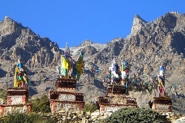
The journey to the pass typically takes around 5-6 hours, with an additional two hours required to reach the summit from Tado Dunga. However, this duration can vary if the trail is covered in snow. Throughout the trek, you will encounter large tent cafes that offer food and drinks to energise and refresh you. The distinct Nara Lagna pass becomes visible in the distance, a challenging climb due to the high altitude. Recognisable by the presence of stone piles and Tibetan prayer flags adorning its peak, the pass grants breathtaking vistas of Tibet ahead while Yari, far below, remains visible.
During the descent, the scenery comprises barren hills painted in earthy brown, ochre, copper, and ash tones. The descent from the pass to Hilsa, marking the border with Tibet, is lengthy and requires careful navigation.
As you traverse this region, be aware of the potential impact of altitude on your physical well-being and ensure you have appropriately acclimatised. It is advisable to consult with experienced trekking guides or agencies familiar with the area to address any specific concerns and to stay informed about local conditions and regulations.
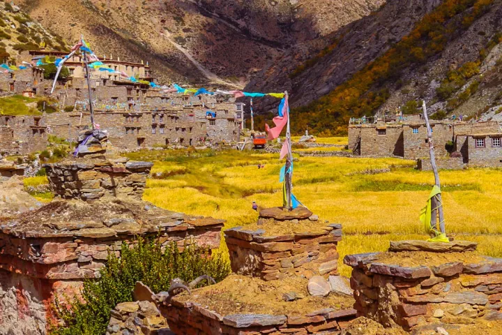
Prayer flags are a common sight in the Himalayas. They are often found strung on passes, high ridges, and bridges above rivers and streams. These colourful flags are believed to carry prayers and blessings to the heavens and deities, carried by the wind that passes through them.
Hilsa is a significant checkpoint on the Tibetan side, particularly during the high summer when numerous Indian pilgrims cross the border to reach Mount Kailash in Tibet. However, we do not cross the Nepal-Tibet border in this particular trek. Instead, after breakfast, we start our journey by crossing the suspension bridge over the Humla Karnali River. From there, we head north along the newly constructed road towards Limi Valley.
Limi Valley is renowned for its wildlife, including snow leopards and Himalayan blue sheep, also known as Bharal. The trek takes us through this captivating valley as we make our way towards Manipeme. After hiking for approximately 4-5 hours, we will reach Manipeme at an elevation of 3930 meters. Manipeme is derived from the Mani Mantra, engraved on a large rock at the campsite. This adds a spiritual touch to the scenic surroundings, offering a unique atmosphere for trekkers to appreciate.
While trekking through Limi Valley and reaching Manipeme, respect the local customs and natural surroundings. Take advantage of the opportunity to experience the region’s tranquillity and watch for the elusive snow leopards and other wildlife that call this area home.
As always, planning your trek with reputable agencies, following their guidance, and prioritising safety during your journey in remote and challenging environments like the Himalayas is advisable.
After departing Manipeme, our journey takes us across the Chenglungma caravan campsite before reaching the ancient cave of Cha-sa Nam-ka Dzong. This cave is positioned just above the hill and is renowned for its convenient location and ample firewood availability, making it a popular overnight stop for traders along the route.
As we continue our trek, we traverse the Trans Himalaya region. Despite being a relatively short distance, the trail from Hilsa to Til is challenging and demands approximately seven hours of trekking. This hike section involves navigating barren slopes with frequent ascents and descents. It’s essential to exercise caution along the trail, as you may encounter heavily laden yaks and sheep returning from the border.
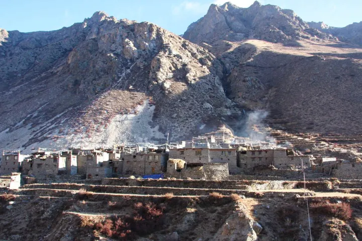
The Limi Valley comprises three main villages: Til, Halji, and Jang. Situated at 4,100 meters, Til is surrounded by lush barley fields on its western side. It is the closest village to the Tibet border and is the smallest settlement among the three. Approximately 30 families call Til home. Notably, Til is home to the Kunzum Do-Nag monastery, a 300-year-old spiritual site on the village’s right side. A visit to this ancient monastery is highly recommended, as it promises to be a rewarding experience.
While immersing yourself in the cultural and natural wonders of Til, respect the local customs, traditions, and religious sites. The trek through this region is an incredible opportunity to appreciate the remoteness and tranquillity of the Himalayas while learning about the local way of life.
Our hike from Til begins with a downhill walk lasting approximately an hour, leading us to Tiljung. At this point, we will arrive at Tagtsi Khola, a tributary of the Karnali River that originates from the east and passes through Jang and Halji villages before reaching Til. We will utilise a suspension bridge at Tiljung to cross the river before continuing our journey to the right.
From Tiljung, our path follows the Tagtsi River as it meanders through a narrow valley to the east. After roughly two hours of walking, we will encounter another bridge spanning the same river. Crossing this bridge, we will proceed on the left side of the river, heading northeast. After approximately 30 minutes, we will arrive at the picturesque village of Halji.
Halji is the largest and most prominent village in the Limi Valley. Its notable attraction is the 800-year-old Rinchhen Ling Gompa monastery, a must-visit site. After exploring the monastery, we will turn east and continue along a broad pathway, passing through a beautiful Buddhist gate and prayer walls. Our journey will extend for around ninety minutes until we reach the village of Jang, situated at an elevation of 3930 meters. The villagers take pride in their 250-year-old monastery, which we appreciate during our visit.
From Jang, we still have approximately one more hour of hiking to reach our final destination: Chagzur Hot Springs. These natural hot springs offer a soothing and rejuvenating experience after the long trek. The total duration of the hike from Til to the Chagzur hot springs is approximately seven hours.
As always, hiking responsibly and respecting the local communities and cultural heritage is essential. Adhere to leave-no-trace principles and follow any guidelines provided by your guides or trekking agencies to ensure the preservation of this pristine environment.
Additionally, take necessary precautions and equip yourself with appropriate gear and sufficient food and water supplies for the duration of the hike. Being physically prepared and taking safety measures will enhance your overall trekking experience.
Staying an additional day at Chagzur Hotspring to relax, do laundry, and enjoy the hot springs sounds like a great option for rejuvenation and rest. It provides an opportunity to unwind and take care of practical tasks before continuing your journey.
Alternatively, if the weather is favourable and you feel energetic, another option is to take a truck ride to Lapcha Syar. This excursion presents a chance to glimpse Mount Kailash and Holy Lake Manasarovar in Tibet, revered sites for spiritual and religious significance. To arrange this trip, you can easily hire a truck with the assistance of local arrangements.
However, it’s important to note that road conditions in Tibet can be challenging, with rough terrains and long travel times. The journey to the viewpoint and back would entail approximately 5-6 hours of travel. It’s crucial to consider the feasibility of this option given the weather conditions, your energy levels, and any potential altitude-related considerations.
If you embark on the truck ride, ensure that you have made appropriate preparations, such as carrying sufficient food, water, suitable clothing, and any necessary permits for border crossings. It is also advisable to consult with your guides or local authorities, who can provide accurate and up-to-date information on road conditions and safety.
Ultimately, the decision to either relax at Chagzur Hotspring or take the truck ride to Lapcha Syar will depend on your preferences, physical condition, and the prevailing weather and road conditions. Both options offer unique experiences, and choosing what aligns with your interests and well-being is vital while considering safety as a top priority.
As we continue our trek from Chagzur Hot Springs towards Tagsti, we will have the opportunity to traverse the ancient caravan trails that connect Humla to Limi and Manasarovar. We will eventually come across a newly established settlement called Tugling, located about half an hour before reaching Tagsti. In Tugling, you will find amenities such as a restaurant and a VHF telephone service, which the people of Limi maintain.
Upon arriving at Tagsti, we have two options for reaching the Nyalu base camp. The first option is to cross the river and follow the new road, which offers a shorter route. Alternatively, we can opt for the longer and more scenic trail that takes us through Tagtsi. If we choose the latter, we will have the chance to observe the ruins of a Limi village soon after we cross the Tagtsi bridge on our right. This village, once known as Tshamdo or Zambuk, holds historical significance as the oldest village in the Limi Valley.
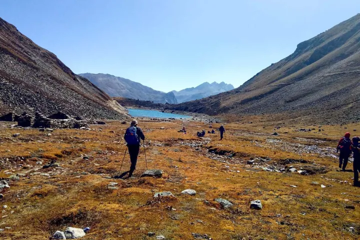
Continuing our journey, we must cross the Nyingchhu River, which flows into Tshomgo Lake. From here, we will be treated to breathtaking views of Tshomgo Lake and the stream that flows through the Talung meadows. Along the route, we will also come across the campsite of Limi and encounter Humli shepherds and yak herders at the Jade/Nyalu base camp.
The duration of today’s trek is estimated to be around seven hours. It’s essential to consider factors such as weather conditions, personal fitness level, and the overall pace of the group while planning for this journey. Always prioritize safety and ensure you are well-prepared with appropriate gear, sufficient food, water, and any permits or documentation required for the trek.
Immersing yourself in the area’s natural beauty and historical significance will make this day’s journey memorable and rewarding. Take the time to appreciate the surroundings and make the most of the enriching experiences.
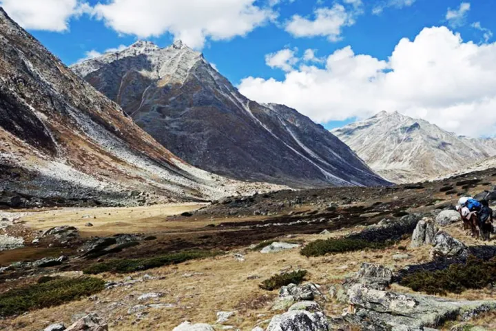
After leaving the Nyalu base camp, the ascent to the top of Nyalu Pass at 4,990 meters will take approximately two to three hours. From this vantage point, we will be rewarded with spectacular views of several peaks, creating a breathtaking panorama that showcases the region’s natural beauty. Moreover, during the descent from the pass, we will encounter a small and picturesque lake called Sheliman Lake, at an altitude of 4,570 meters.
Continuing our trek, we will make our way towards Tshongsa meadow at an elevation of 4,140 meters. As we traverse the landscape, we will cross the Tshongsa River and re-enter the treeline, surrounded by a flourishing rhododendron forest. Along the hike, we will pass by imposing Tshongsa rocks, adding to the grandeur of the surroundings. Additionally, we will be captivated by the sight of the stunning Tshongsi Tsan waterfall, also known as the wild Demon of Tshongsa.
Around an hour beyond the Tshongsa rocks, we will reach Sheng Jungma, a picturesque pastureland. This serene location provides a peaceful setting to soak in the natural surroundings. Finally, after a 7-hour trek, we will establish our campsite in a dense forest. The tranquillity of the forest, combined with the sense of accomplishment from the day’s hike, will create a serene atmosphere for camping and resting.
As we venture into the thick forest, it’s essential to ensure that we have suitable camping equipment and adequate provisions and adhere to proper campsite practices. Being well-prepared will contribute to a comfortable and enjoyable experience throughout our trek.
Embrace the beauty of nature and take the time to appreciate the diverse landscapes and landmarks accompanying us on this portion of the trek. The combination of majestic peaks, enchanting lakes, lush meadows, and cascading waterfalls makes for a captivating and rewarding expedition.
While trekking through this region, our route will lead us across the Tshongsa River. As we begin our journey, we will be on the left bank of the Zhetse Khola, heading towards the east. Along the way, we can visit the summer camp of the Chyadok villagers, who are local herders residing in the area. This visit provides an insightful glimpse into the traditional herding practices and the way of life in this region.
Continuing our trek, we will be treated to the stunning landscape of the Zhetse Valley. The panoramic views of this valley will encompass its natural beauty, including its lush green meadows and surrounding mountains. As we progress further, we will reach the campsite of the Dinga village herders, also known as Langdogd Base. This campsite is a resting place for the herders and presents another opportunity to witness the local herding culture and their symbiotic relationship with the land.
Following our exploration of the Dinga village herders’ camp, we will cross the stream again, returning to the right side of the river. This crossing will require us to go upstream for approximately 3-4 hours. This part of the trek allows us to immerse ourselves in the serene surroundings and appreciate the area’s natural beauty.
As we embark on this leg of the journey, it is essential to remain mindful of the natural environment and adhere to responsible trekking practices. Respect for the local community and their surroundings is crucial, ensuring this beautiful region’s long-term sustainability and preservation.
Embrace the unique experiences that await us along the Tshongsa River, from encountering local herders to witnessing the mesmerizing landscapes of the Zhetse Valley. Each step brings us closer to a deeper connection with nature and an appreciation for the area’s rich cultural heritage.
Leaving the campsite behind, our next destination is Langdogd Pass, 4,550 meters. The ascent to the pass takes us through a dense forest, where caution is advised due to the steep terrain. We must tread carefully as we navigate the forest, ensuring our safety as we make our way towards the pass. The forest is adorned with juniper and birch trees, enhancing the natural beauty of the surroundings.
Once we reach the top of Langdogd Pass, our descent begins, and we must be mindful of the steep and challenging terrain. The descent will lead us through the captivating juniper and birch forests, offering a mesmerizing display of flora. Continuing our trek, we will eventually arrive at the Takhor Khola, a river we must cross. Care and caution should be exercised during this river crossing to ensure a safe passage.
After successfully crossing the Takhor Khola, our hike continues for approximately ninety minutes, leading us to the enchanting campsite of Laga Dinga, also known as Lekh Dinga. Set at an altitude of 3,890 meters, this campsite holds historical significance as it once served as the autumn trading center for the southern people of Humla and the Limi valley. The area is characterized by its natural beauty, providing a pleasant and serene atmosphere for us to spend the night.
Take this time to appreciate the tranquillity of Laga Dinga and immerse yourself in the region’s rich history and cultural significance. Engage in responsible camping practices, respecting the environment and leaving no trace behind.
As we settle into our campsite, let the allure of Laga Dinga captivate you, making it a memorable stop on our trekking expedition.
Our journey continues as we embark on a scenic route, passing through several villages and ultimately reaching Simikot, the district capital of Humla. Starting our day, we will encounter the villages of Yapka and Tangin, situated on our left, while Aul Dinga (Lower Dinga) village lies on our right. These villages offer a glimpse into the local lifestyle and culture, adding to the cultural richness of our trek.
From there, we begin our climb towards the Thakuri village of Okhreni. The ascent will take us a little over two hours, rewarding us with panoramic views of the surrounding landscapes. As we reach Okhreni, we can immerse ourselves in the unique cultural atmosphere of this Thakuri village, observing their way of life and engaging with the locals.
Following our time in Okhreni, we embark on a steep descent for approximately an hour and a half, eventually reaching the Yapka Khola, situated at 2,600 meters. The descent requires careful navigation due to the challenging terrain.
Continuing our expedition, we hike for an additional three hours along a newly constructed road until we arrive at Simikot Lagna. This leg of the journey treats us to breathtaking views of the Nyinba Valley, enhancing our appreciation of the natural beauty surrounding us.
To complete the trek, we walk downhill for fifteen minutes before reaching Simikot, the district capital of Humla. Here, after two weeks of camping, we can enjoy the comforts of civilization. A hot shower and a bed in a guest house await us, providing a well-deserved respite from our camping adventures in the wilderness.
Simikot serves as an excellent base for further exploration or as the endpoint of our trekking expedition. Take the time to rejuvenate, reflect on the remarkable experiences of the past weeks, and appreciate the diverse landscapes and cultural encounters that have enriched our journey.
Remember to respect the local customs, traditions, and natural surroundings throughout our time in Simikot and leave a positive impact on the community as we conclude our trekking adventure.
As our trekking journey through the remote part of Nepal comes to an end, we begin the process of returning to Kathmandu, the capital city. We will catch a flight from Simikot to Nepalgunj to facilitate our return. After an early breakfast, we make our way to the airport, ensuring a smooth departure.
Upon reaching Nepalgunj, we will have a connecting flight to Kathmandu in the afternoon. Utilize this time to relax and reflect on the incredible experiences and memories gathered during our trek. Take advantage of the opportunity to appreciate Nepal’s diverse landscapes, cultural encounters, and natural beauty.
Arriving in Kathmandu, we are welcomed back into the bustling city atmosphere. This vibrant capital is known for its rich history, culture, and warm hospitality. We can take this time to explore the city further, immerse ourselves in its architectural wonders, try out local cuisines, or relax and unwind.
After the physically demanding trek and weeks of camping, we can indulge in the comfort of a hotel, enjoying modern amenities, a hot shower, and a comfortable bed. Take this time to rejuvenate and reminisce about the journey, sharing stories and photographs with fellow trekkers.
As we conclude our trekking adventure and return to Kathmandu, let the memories and experiences of the remote Nepalese landscapes and the warmth of its people stay with you. Cherish the connections made, the challenges overcome, and the beauty witnessed throughout the journey.
Time for farewells. We hope you enjoyed the time in Nepal with us.
Inclusions
- Boutique hotel in Kathmandu with breakfast
- Mentioned sightseeing.
- Private vehicle
- Domestic flights
- 3-men tent (for two trekkers) for the trekking part
- Expert trek leader or hire Raj
- Trekking chef
- One assistant guide per 4 trekkers
- Chef’s assistants
- Porters to carry all camping gear, food, and equipment
- All meals on the trek – the best and healthiest food in the Himalayas.
- Toilet tent.
Exclusions
- International airport taxes
- Visas
- All optional additional tours or activities during free time
- Transportation outside of the tour program
- Travel insurance (compulsory to have insurance that covers helicopter evacuation)
- Tips (suggested amount US$150 per week for staff only); Leader’s tips at your discretion
- Items of a personal nature, e.g., alcoholic drinks, bottled beverages, laundry, souvenirs, etc.