Everest base camp trek with the highest golf tee offs by a foreigner
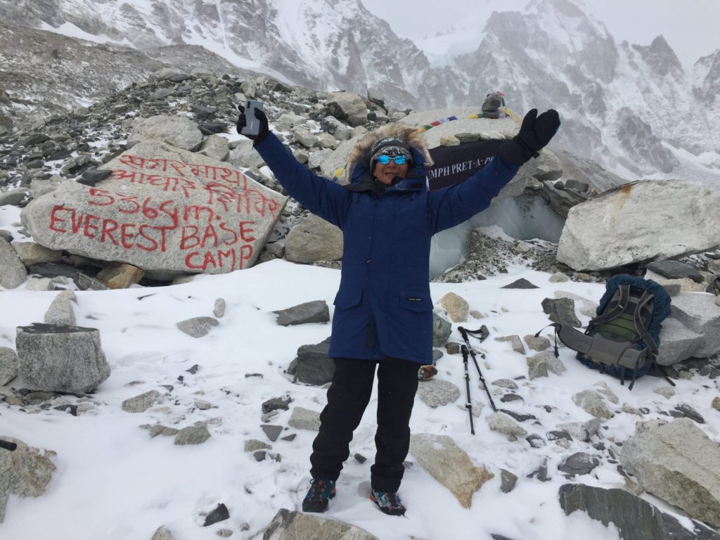
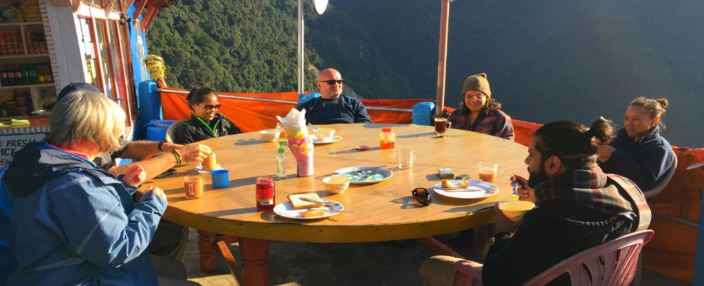
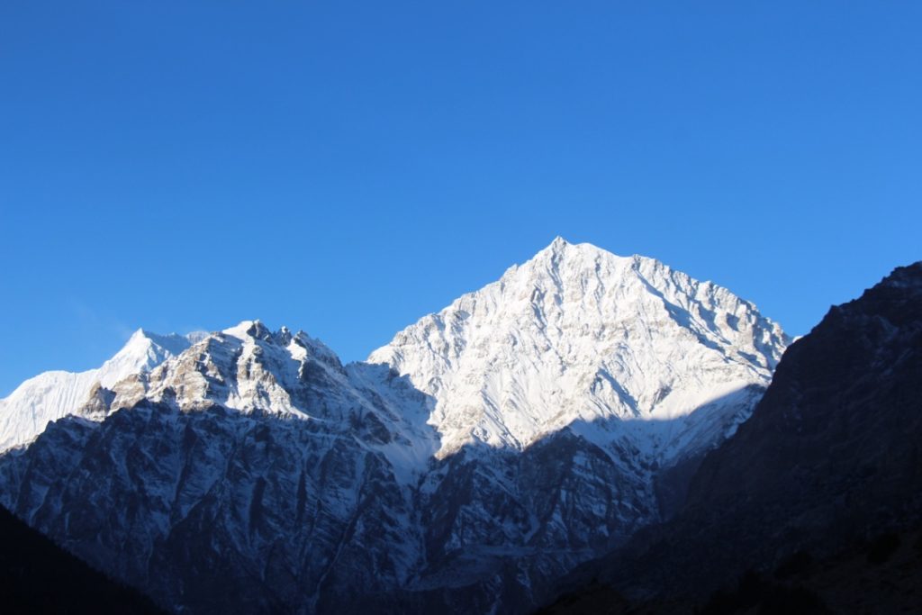
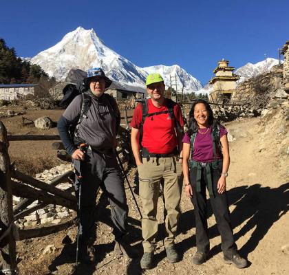
Everest base camp trek with the highest golf tee-offs by a foreigner. I took Harry Tan, a 71-year-old trekker from Singapore, to Everest base camp on a trek (not a climb to the top). I devised the idea to make this a trek to Everest base camp with a twist. This idea came to me on the morning of 7th December as he was flying here to make him tee off from 3 places above the altitude of 5000 meters. I had known him since 2015 when he came to golf with members of the Seletar golf club before the massive earthquake on 25th April 2015. He did a short trek in 2016 and was here in March this year with other club members. He is a keen golfer and part-time Physical Education teacher at Nanyang Technical University. 8th to 13th December 2019. We did this trek on our regular itinerary by flying to Lukla, trek to Namche, a side acclimatization trek to Amadablam base camp, etcetera. We hiked to Dingboche according to our plan. It started snowing lightly on the 6th morning from around 6.30 am. Upon reaching Dingboche, we stopped in a shop so Harry could buy warmer gloves, as the two pairs he brought from Singapore were not doing the ‘job.’ So instead, he ended up buying a pair of feather mittens. We just hung around the lodge, eating/drinking hot food and beverages. It continued to snow lightly for around 22 to 24 hours with occasional short breaks. 14th December 2019 We started our hike on a partially cloudy/foggy morning in the snow between 30 and 50 centimetres in depth. Despite December being the slow season, 70 to 100 other trekkers were on the trail. We reached our destination Lobuche 4940 meters, at 4 pm with the boots all damp. 15th December 2019 This was a massive day as Harry would be teeing off from 2 above 5000 meters. It began snowing lightly from 7 am, with the wind swirling up the valley behind us, blowing snow/sand. We hiked for about 90 to 100 minutes before reaching the flattish ground on Lobuche pass to Gorakshep 5180 meters. We stopped to bring out our 3 Wood driver, rubber tee, and an ecobioball manufactured by Albusgolf. These balls were imported from Europe 3 years ago for my project. It was a complete whiteout when Harry did the first-ever 5000-meter tee-off by a foreigner, a fellow Singaporean; Mark arrived just in time to witness this feat. We became friends six days ago in Namche Bazaar and crossed paths regularly on the trail. We continued on the lateral moraine towards Gorakshep. We had a quick lunch and left for the Everest base camp. We were the last to reach EBC and planned to avoid unnecessary attention from other trekkers. However, the other trekkers talked about a Singaporean with a golf club and wondered what he would do with it. We reached EBC trudging through snowy/icy conditions with strong wind gusts. Harry had to practice his swings with five layers of jackets in cold and windy conditions, not an easy feat for someone from sea level and a warm tropical country. Nevertheless, he managed to get an excellent swing. We headed back to Gorakshep for the night. Unfortunately, we learned that the overnight temperature was between -18 to -20 degrees Celcius. 16th December 2019 This was another significant day as Harry was going to tee off from Gorakshep at 5180 meters, and as it was a very clear day, once more from Lobuche pass. So Harry teed off from Gorakshep and Lobuche pass (a world difference between a foggy morning and a bright sunny day). We stopped at Pheriche and not Pangboche as planned due to the conditions of the trail. We had been walking on snowy/icy trails for the fourth day. 17th December 2019. We had planned to reach Namche Bazaar on this day. Instead, we had a gloriously bright morning with 360-degree views. Shomare the first settlement after leaving Pheriche, took us nearly two hours in snowy and icy conditions. On regular days it is only a 45-minute hike. There are patches of very icy trails where communal taps are left running to avoid pipes bursting below freezing temperatures. Before reaching Pangboche (standard time 90 minutes), which had taken us more than 3 hours, I gave Harry the option of flying down to Lukla by helicopter, bypassing these treacherous conditions and avoiding getting injured. Harry was happy to fly by chopper as it would also be his first experience. First, however, we had to wait a few minutes for the helicopter to bring cargo on a sling to arrive, leave the load, and get us to Lukla. We arrived in Lukla after a short 7 minutes but a thrilling flight by helicopter. We had a relaxing afternoon in Lukla, basking in the sun, having a warm shower, and the last night’s party with our talented staff Sundar Rai. 18th December 2019. We got to the airport terminal at 8 am and had a three-hour delay. We had to wait in the cold airport terminal. We were happy to leave Lukla when our aeroplane finally arrived. Harry was dropped off at his airline office to change his flights and was free to sort out his things for the afternoon. 19th December 2019 We dropped into the airline’s office to upgrade Harry’s flight before heading to the airport. Finally, we bid adieu at the airport; another innovative adventure ended. Conclusion. We are trying to get a few media companies to print this story. No matter what others may think or say, I think this achievement is no ordinary feat. It is unlikely to be matched or beaten for some time to come. The combination of a 71-year-old foreigner, trekking to EBC in the winter snow, and teeing off above 5000m is a difficult act to put together. This story of this incredible feat was published in a reputed National weekly
Upper Mustang trekking general information
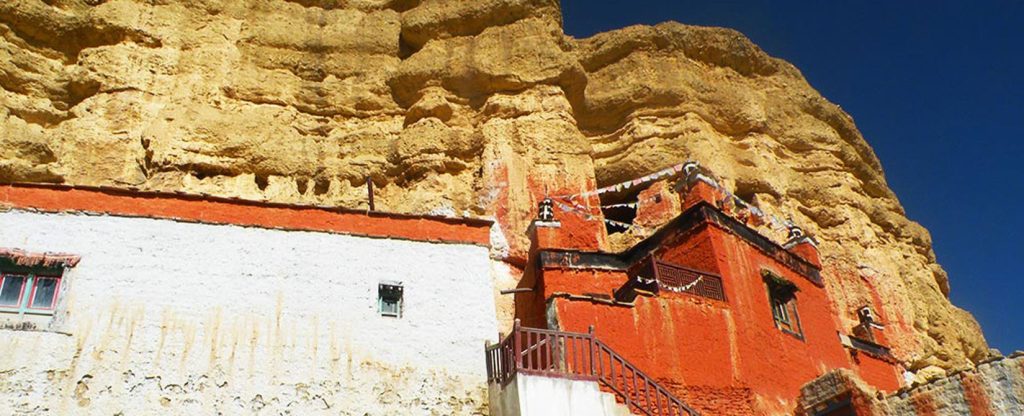
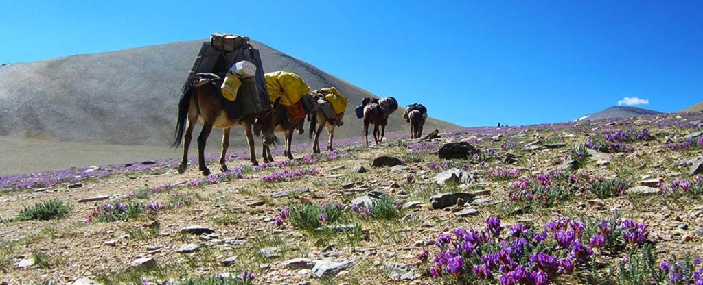
Upper Mustang trekking – General information The Upper Mustang region lies in the Northern part of the Mustang district in Nepal. It used to be one of the famous trading routes between Nepal and Tibet. The people of Mustang practice Tibetan Buddhism and speak a Tibetan dialect. It once was an independent Kingdom from 1380 until it was annexed into Nepal in the 18th century. The people of Upper Mustang practice animal husbandry, trading, and some limited seasonal farming. Farming was always limited due to its position in the Trans Himalayas with a semi-arid climate. However, the receding glaciers have made it even more difficult to cultivate in this high land in recent years. So much so that some villages have been abandoned, and the inhabitants have migrated elsewhere: ironic for the place called Smon-Thang in Tibetan, which means fertile plain. For more details about Upper Mustang To reach Upper Mustang, one must travel northwards of the Kali Gandaki Valley, the most in-depth ravine globally, with Mount Nilgiri 7055 meters – 7134 meters and Mount Dhaulagiri 8167 meters, the seventh highest peak in the world to its South. The average altitude of the Mustang is around 4000 meters. The capital, Lo Manthang, is a walled city. Trekkers were only allowed to visit the Upper Mustang in 1992. Nepal government charges a special area permit of US$500 for ten days and $50 for every additional day in this area. A liaison office must also accompany the visiting international groups to keep close supervision to protect centuries-old local traditions and cultures. Due to this high permit fee, less than 1000 trekkers visit this region every year. Only the Bonafide Trekking companies of Nepal can obtain this special area permit. For more on Lo Manthang Lo Manthang is known for its high whitewashed mud-brick walls, Gompas, and the King’s five-storey palace. It is believed to have been constructed in the 15th century. There are four significant Gompas within the walled city. An average trekking duration depends on the number of stops made in various villages. However, you can do a comfortable 10-15 days round trip journey to Upper Mustang. It involves trekking on dry, dusty trails with several passes to go over to reach Lo Manthang. The road from Tibet already got Lo Manthang in 2001, and a fair-weather highway is under construction from Jomsom, the administrative headquarter of Mustang District. Due to road construction, locals have turned to ride motorcycles or horse riding. Upper Mustang is still mysterious and surreal. Please visit Upper Mustang while you still have a chance to discover its unspoiled beauty. We do organize a hassle-free trekking holiday to Upper Mustang. The King of Mustang, Jigme Paljor Bista, passed away on 16th December 2016, aged 86. This article is by Raj Tamang, Chief Experience Officer of Responsible Adventures. Check out our Trekking packages for Nepal, Bhutan, India, and Tibet.
Juphal to Jomson Trek Upper Dolpo Traverse
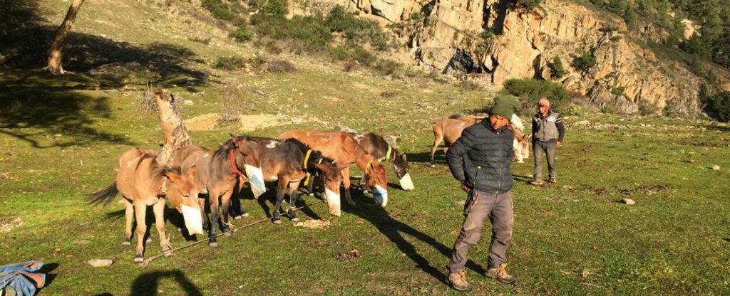
Upper Dolpo Traverse – Juphal to Jomsom September/October 2017 The trek was finally confirmed after months of correspondence back and forth in August. We had our first ever Polish group consisting of 5 members. Trekking Staff movement – Pre trek. This trek is in the High and Wild part of Nepal and takes a lot of planning. I had been planning for weeks on end. Our staff, who spend most of summer monsoon trekking in Ladakh, got back five days, and Dil got into Kathmandu one night before leaving for Dunai, Dolpo district’s administrative centre. These poor lads had to take four days’ drive, changing four vehicles as there are no bridges over the swollen rivers, porter the gear and food to the other side, load it onto another transport, and continue their bumpy ride. After four days of the hot, sticky, rough, and sometimes bruising ride, they had to load the equipment and food on mules and continue their journey on foot for two days. They finally got the Dunai on the 6th day. They still had to sort out the rental tents and kitchen equipment and go shopping for fresh vegetables before we arrived. Upper Dolpo Group movement One group member pulled out due to compassionate reasons on the day she was to fly towards Nepal. One group member arrived via Delhi in the morning, while the rest arrived via Doha. Upon arrival at the hotel, the standard check-in, I arranged for the money changer to come to the reception area with local currency for the trekkers as part of our service. We parted ways after agreeing to meet the following evening for dinner and updates. They were left on their own as they all had been to Kathmandu at least twice before, and they knew their way around town. We met for dinner at an agreed time, the trekkers got briefed on the program for the next day, and we flew to Nepalgunj in the afternoon. The flight to Nepalgunj got delayed by 30 minutes, but a brand new old ATR72-500 of Yeti Airlines made up for the lost time. The aircraft was filled with two big groups of medical/missionary volunteers to the Humla district. It was hectic trying to retrieve our luggage while being eaten alive by mosquitoes. The heat and the humidity didn’t help much. It was a relief to get to our hotel’s air-conditioning – Traveler’s Village, just a few kilometres from the airport. We retired early, as we had to get to the airport by 5.30 a.m. for our flight to Juphal. We collected our packed breakfasts, loaded the vehicle with our luggage, and headed for the airport. The airport was buzzing with activity. Upon checking in, I was informed that we had 74 kilograms of excess weight and had to pay RS150 per kg. Upon doing so, I joined the group after the security check, and the weather had worsened; it had started raining. We were informed that the flight was cancelled due to bad weather at Juphal. The airline crew we had booked our plane had a day off the next day, and they wouldn’t fly. I called up contacts to convince them to pass the next day or get seats on another airline but to no avail. We were fortunate to have understanding clients who said there was no need to get stressed out if the flights were not happening. We spent the next day touring around Nepalgunj; mind you, most locals we spoke to said not much to see here. We returned to the hotel in the afternoon after sending the morning in an electric vehicle. Day 1 The following day we got into our aircraft, and in a short time, we landed at Juphal airport. We decided to walk part of the way until our vehicle met us on the trail; we walked to Dunai. We expected the weather to be much colder above 2000 meters, but it was still scorching. We were glad to be united with our team, who had been waiting for us and had a quick discussion to get moving that day after a quick lunch. Our group consisted of me as the trek leader, two trekking chefs, one trek butler, one local assistant, two pony men, and ten mules. We started along the Thulo Bheri River and turned northward an hour later along the Suligad River. We registered with the Shy Phoksundo National park at their entrance, the largest in Nepal. We got to Kageni just before dark as we had a late start to the day. Our crew and mules reached the campsite 30 minutes after we did, and they quickly set up the tents for the trekkers and made dinner within 90 minutes of our arrival. Day 2 The following day we walked in a northwesterly direction going upstream of the Suligad river, which comes from Phoksundo Lake. The hike was in the beautiful forested area passing through Shyanta and Chepka until our final stop at Rechi. Our mules and support crew got delayed as one of our mules brushed against a rocky outcrop on the trail and fell into the Suligad River. Our pony men quickly jumped into the waist-deep river and pulled the mule out. The mule escaped with no injuries; its load, two tin boxes, was utterly smashed. Once again, they arrived just before dark, but like the previous night, our team was swift in preparing our dinner, and everyone went to bed content.
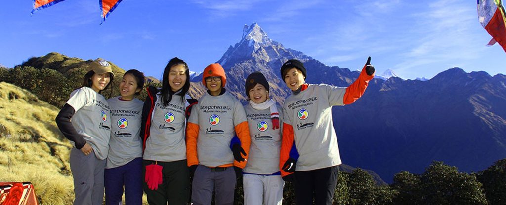
Charity Trek to Poonhill for autistic children of Bahrain.
Charity Trek to Poonhill for autistic children of Bahrain. 27th – 3rd November. A friend from Bahrain contacted me to organize a Charity trek to raise Alia National School funds in Bahrain. Alia National School is for children who have autism and Down syndrome. This was the second time a charity trek was organized to raise funds for this school. The first time was arranged in February 2011. A group of 8 trekkers came from Bahrain. The group consisted of 4 Bahrainis – a family of 3 and a single Bahraini gentleman, an English couple, A Swedish gentleman, and his Filipina wife. The whole trip was just a week long. Most of them arrived a day earlier than the planned day. Kathmandu to Pokhara drive. We left early at 7 am to avoid the heavy traffic coming out of Kathmandu valley in our private van. Our driver took us through the back roads avoiding the main highway. We were out of Kathmandu valley in an hour; I have heard stories of how it has taken as much as 5 hours to get to their homes once they reach the valley. The drive was relatively uneventful, with a few toilets, a coffee break, and a lunch stop at Gunadi, about 40km outside Kathmandu. Despite being a mere 200 km distance, the winding road takes about 7 hours to reach Pokhara from Kathmandu. A couple of group members ran to our hotel’s bar when we arrived. We checked in and agreed to meet in an hour to walk, do some hiring of trekking gear, and window-shopping. Most of us stuck together for a dinner of Galette and barbecue at the French Creperie, Khahare, Lakeside, Pokhara. The Trek. We left Pokhara after breakfast on a 90-minute drive to Nayapul, where we alighted from our van and got into three jeeps for a further 45 minutes of the off-road ride to our starting point of the trek. Our support staff of porters, assistants, and our trekking chef waited for us at Nayapul, where we changed vehicles. Our support crews were introduced to our trekkers before we started our trek. The first 25 minutes of our tour were undulating with short ascends and descends until the village of Tirkhedhunga. I came to learn that one of our trekkers was afraid of heights. However, she crossed two steel suspension bridges within the first 30 minutes and three more wooden bridges until the end of this trek. The following two hours were a steep uphill climb on Ulleri village steps, where we stopped for lunch. We had a relaxing lunch break that was 2 hours long. The lodges make their food freshly after it has been ordered. It can take between one hour to ninety minutes, depending on how many different dishes are ordered and the number of trekkers who have ordered their meal. We only had one more hour of trekking before we stopped for the night at Banthanti. The Hike to Ghorepani. We woke up to a bright morning after a windy night, which blew away the clouds making the Himalayan peaks visible. The hike takes place in a beautiful forest setting at a much gentler gradient. The trekkers stopped for numerous photos in the picturesque setting. The forest we walked through is radiant with beautiful Rhododendrons and Orchids during spring. We stopped for an early lunch at Nangethanti as the walk was only three and a half hours long. Our trekkers from Bahrain enjoyed the warmth of the sun, and a couple of them enjoyed a bottle of beer. The beautiful forested walk continued for another 90 minutes before we reached Ghorepani. Ghorepani is set on top of a hill with stunning views of the Dhaulagiri and Annapurna range on clear days. It was cloudy when we got there. However, some peaks became visible as the air temperature became more refreshing when the clouds descended. Poonhill for Sunrise. We got up at 5 am and left the hotel at 5.20 am for Poonhill for sunrise. We could see a line of headlamps both in front and behind us. Ghorepani has many lodges, and it is one of the most popular spots for trekkers. It is a junction for trekkers to come from 3 directions. We saw that it was a foggy morning as the early light hit us on the way to Poonhill. Several groups of trekkers were on their way down as it was both hazy and cloudy. We heard cheers from the excited trekkers when the views got clear as we got close to our destination. We arrived on time for the clouds to clear up in time for sunrise. Our team treated the trekkers to a cup of hot chocolate, which was much appreciated. We returned to Ghorepani after admiring the views and having taken photographs. We finished packing up our duffel bags before having breakfast. Trek to Tadapani. This was going to be the longest day for the trekkers from Bahrain as we had hiked an hour to get to Poonhill, 45 minutes down for breakfast, and we had four and a half hours more to go. We started the hike with an ascent up to Deurali pass and began descending to Banthanti, where lunch was pre-ordered by our staff. It was chilly, and the weather had turned cloudy at Banthanti. We were glad to be moving after lunch to get warm. We had 20 minutes of undulating terrain in a Rhododendron forest before descending to a small stream; the final leg of this day’s hike was a 45-minute climb to Tadapani, our destination for the night. Everyone in the group was tired and went off to bed by 7.10 pm after dinner. There was some family feud going on at the lodge where we stayed. Most of our group members heard when they first went to bed but soon fell asleep; that was how tired they were. Our staff had to go and ask the family to stop
Nar Phu trek during the spring season
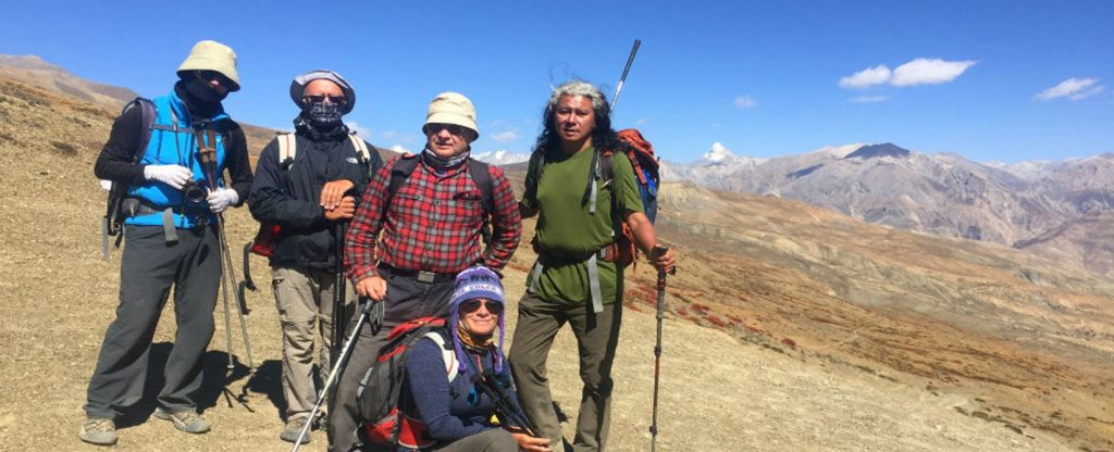
Nar Phu Trek during March/spring season Nar and Phu Valleys are located in a remote part of the Manang district on the Annapurna Range’s Northside. It is in what the Nepalese government calls the “Restricted Area,” where special permits are required and obtained by bonafide Trekking agencies of Nepal. This area was opened to foreigners in 2003. The trek’s duration depends on the trekking group’s time and fitness level, opening up a few options. It’s time for the actual trekking part. If you have plenty of time between 3-4 weeks, you can choose to drive to Besisahar and start your trek to Koto on the main Annapurna Circuit trail. The hike takes four days to get to Koto. Then, you branch north to the restricted area of Nar and Phu from Koto. You can come out of the “restricted area” via the more challenging and higher way via Kang La pass 5360m to Ngawal on the Annapurna Circuit trail or retrace your steps back to Koto. If time is not a problem, you can continue towards Tilicho Lake and go over the Thorung La pass to Pokhara. Otherwise, you can take a jeep from either Ngawal or Koto (depending on your itinerary’s choice) back to Besisahar and return to Kathmandu. Our group from Singapore had a short time to do this trek, so we did the quickest and safest possible itinerary for them. Here is an article about the Nar Phu trek we conducted for our Singaporean Group. Style of Trekking – Camping. Our trek to Nar Phu valley was going to be an entirely supported expedition-style camping trek. A camping trek requires many logistics as all camping equipment, food, and provisions must be reorganized and carried throughout the trekking trip. Why do a camping trekking tour The Nar Phu valley trekking area is newly opened and isn’t as developed with lodges/teahouses as the Annapurna, Langtang, and Everest regions. One has to be very fit to do a lodge trek in this area as the distances between villages are far, especially during the early spring. Most villagers wouldn’t have returned from the warmer lowlands to avoid the harsh winter. Camping trek is a better option if you part of a larger group – 4 or more persons as some village lodges have only two rooms for trekkers. In addition, a camping trek gives your group flexibility, e.g., if some people in your group are not as fit or not well, your team can set up camp before the predestined location provided they find a suitable campsite. The support team. We had a team of a Trek leader (yours truly), three assistants’ guides, a trekking chef, three kitchen assistants for the chef, 12 mules, and a mule driver for a group of 9 trekkers for a 10-day trip. Day 1) Our group from Singapore arrived in the afternoon. There were met at the airport and brought to their hotel for the pre-trek briefing. We met at the hotel lobby at an agreed time to go for dinner. We finished our meal and parted ways to rest due to their very early start to the day. Day 2) Despite being on a tight schedule, we had to keep this extra day in Kathmandu as the Department of Immigration requires the original passports for the restricted area permit. While the trekking permit was being organized, the group went on a walking tour of Swayambhunath Stupa and walked through the back streets of Kathmandu into Basantapur Durbar Square – a World Heritage site before heading back to Thamel, the tourist district, for lunch. Once we ordered our lunch, the group was briefed on the journey’s timing the next day, what to expect on the trek, how our team delivered our service, etc. The trip briefing is done to save time while waiting for the meal to arrive. Our permits were issued by the end of our lunch. After that, we parted ways so everyone could return to final repacking for the trek as we had a very early departure. Day 3) We had requested an early buffet breakfast at the hotel as we had two sections of driving for the day, which could take anywhere between 12-14 hours. While the group had breakfast, our staff loaded their trekking kitbags onto the van doing the journey’s first leg. The first part of the trip was to Besisahar – a mere 145km drive, but the winding road took 5 hours to reach. After that, we were to change vehicles and get into three jeeps for the rough track to Koto. The automobiles got loaded up while the group had lunch at Besisahar. It was a very tight squeeze with our nine trekkers, nine support crew, our camping gear, and food. Our team had left for Besisahar the previous day as they had to shop for fresh fruits and vegetables and organize the packing. We arrived at Koto after dark at 7.30 p.m. The drive is very scenic, but the rough road is bone-jarring. However, the local drivers say the more load the jeeps have, the less bumpy the ride is due to the weight. We had another early night after dinner at the lodge. The Nar Phu Trekking begins. Day 4) We had ordered our breakfast the previous night to save time the following morning. We woke up to beautiful views of Annapurna II and Lamjung Himal. We had to check in with the police post with our special permits before entering the Nar Phu Valley. We left the Marshyangdi Valley a short hike later and joined the Nar River Valley. The walk is along a wooded area with a combination of an undulating trail but gently gaining altitude. We had started at 2600 meters, and our camp was going to be at 3200 meters. Most people head for the village of Meta at 3560 m, but we had planned to end our day two hours before that at Dharmashala (a resting place for travellers).
An epic adventure of Mardi Himal Trek and paragliding to Pokhara
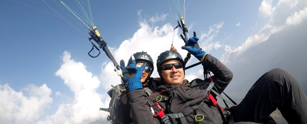
An Epic Adventure – Mardi Himal Trek and Paragliding down to Pokhara In October 2015, my good friend Babu and I sat in Pokhara – a town West of Kathmandu, to discuss joining hands to offer an epic adventure of trekking on the Mardi Himal route and taking off from 3500 meters or higher if the weather allowed. It is an innovative epic adventure, providing another unique experience for our esteemed customers. I was approached by some keen Nepalese youths with a thirst for unique adventures some 18 months ago and again in early November 2018 while I was leading another tailor-made Ghorepani to Jhinu danda trek. It took some organizing amidst some obstacles, such as being between two major Hindu festivals and a world accuracy paragliding championship taking place simultaneously. However, everything was finally sorted out after several days of frantic phone calls. Mardi Himal trekking route has been used as a high-altitude training flight for new pilots, but a commercial tandem flight for a group was probably the first time, at least for Nepalese clients. There were six interested, but two had to return to their hometowns to get back to their businesses due to time constraints. I met all six at Pitam Deurali on the 11th morning, having flown to Pokhara from Kathmandu the previous day. The two who had to return bid farewell to the five of us going on this epic journey. We had planned to trek for three days to high camp instead of two to give them time to acclimatize well; most importantly, the weather forecast would be cloudy for the first three days and clear on the 15th of November. Trek to Forest camp 2465 meters. We trekked amidst lush forest on the first day we got together – the team had arrived at the Australian camp two days prior and had hiked to Pitam Deurali the previous day. There were a lot more Nepalese trekkers than those from overseas. We soon learned that Dashain and Tihar’s holiday period is very busy with the newly adventurous Nepalese. It was good that I had booked all the lodges in advance as some trekkers had to continue to the next place when all the rooms at Forest camp were overbooked. So we took a relaxed pace with a stop for a light lunch in the middle of the forest before reaching our destination for the night. Trek to Badal Danda 3185 meters. We had a relaxing breakfast before starting our trek as we only had about a 4-hour hike on this day. The trekking trail was already busy with trekkers who had started earlier and wanted to get to High camp to get a bed to avoid sleeping in the dining room. The hike was through a forest, listening to the numerous birds singing in the trees and flying. We stopped at Low camp for lunch and to charge our power banks and electronic devices. Unfortunately, there is no direct power above the low base, and the weather forecast was cloudy for another two days. We took a very long lunch, and the four friends were busy joking and laughing. We reached Badal danda around 4.30 pm. Only three other trekkers and their guide at the lodge I had booked. We learned that morning; it was clear only until seven a.m before the clouds covered the mountain views. Trek to High Camp 3566 meters. I could see that the views were going to be clear for some time at 4.30 am. It was a starry night, with the Annapurna range visible even that early. I got out of bed before 6 am to take photos; this is a magical time for photographs of the mountains and the sunrise. We left for High camp after breakfast with a couple of stops, as this day’s hike was only two hours long. We took a long break at the new lodge on the upper part of Badal Danda to enjoy a lovely cup of fresh coffee as we were not in any rush. However, I managed to get in touch with my paragliding counterpart. I learned there would be 12 solo pilots for their high-altitude flight and five tandem pilots for us; a total of 17, and I met a couple of other overseas pilots on the way. There was a lot of movement from trekkers returning towards Pokhara after going up to the “View Point” by getting up at 3 am for the sunrise, and others who, like us, we’re going to high camp. Finally, we arrived at High Camp and ordered our dal bhat lunch – all five agreed that it was the best meal to date. It was foggy, windy, and cold at high camp. We spent the rest of the afternoon wrapped in blankets, talking, joking, and playing games in our room. Then, finally, we went to bed excited for the epic adventure we would partake in the following morning. Paragliding from Mardi Himal High camp to Pokhara. Once again, I got up at 4.30 am and was pleased to see that the clouds had gone much lower than the previous days, and the mountains were clear with glittering stars all around. We left the room to admire the gorgeous views and take photos. Unfortunately, we only had time to wash up and have a cup of coffee when the pilots started hiking into the high camp at 7.15 am. After that, we had to pack our backpacks and get ready to take off as the clouds began rising. We soon learned that the pilots had left Pokhara at 4 pm and started hiking for 7 hours before stopping at 2 am when they reached Badal Danda. They started walking again at 5 am to get to High camp. There was a flurry of activities of the pilots spreading their gliders, other trekkers gathering to watch – it was fascinating for everyone. Soon the solo pilots started taking off while the tandem
What to expect on the Mardi Himal trek
What to expect on the Mardi Himal Trek In the 80s, only a handful of trekking companies organized camping treks to this region’s expedition-style camping treks. However, as recently as 2011, some lodges have opened up at strategic points for trekkers to do lodge/teahouse trekking to Mardi Himal. The area lies east of the Annapurna base camp trekking trail. It is the right combination of walking through some villages on the famous Annapurna trail, secluded forest, open ridges, and rugged mountain terrain with Mount Machapuchhare’s (Fishtail) shadow. As a result, this trek is fast gaining popularity with trekkers both from overseas and locals. Mardi Himal Trek is an excellent alternative to the ultra-popular Poon Hill trek with fewer trekkers, gaining popularity. However, the lodges are very basic, with a similar food choice on the menu, as on the main Annapurna trail. The trails can be pretty secluded with some signboards with arrows pointing to the next destination. Here is a sample itinerary for this trek. Day 1: Pokhara to Kaande, Pothana 1900 meters, or Pitam Deurali 2300 meters. You can either get into a local vehicle or rent a private transport to drop you off at Kaande – an hour’s drive from Pokhara. From Kaande, it is a steep 2-hour ascend to the Australian camp passing through small villages at the beginning. On clear days terrific panoramic views can be expected at the Australian camp at 2100 meters. You can either stop for some drinks or have lunch here when you arrive here. If you come here early, you can hike down towards Pothana village as another option for lunch. The hike is through a forest until you reach Pothana 1900 meters. You can either stop here for the night or climb a little under an hour to reach Pitam Deurali 2300 meters. The lodges here are very basic except for one new one that was ready in spring 2016. It makes the next day’s trek to Forest camp a shorter hike. It can take as long as 7 hours from Pothana. Day 2 Pothana / Pitam Deurali to Forest Camp (Kokar) 2600 meters. It would help if you took a packed lunch and enough water to last you the whole day as there is no lodges or tea house to stop for refreshments on the forest trail. It takes around 6-7 hours from Pothana and 5-6 hours from Pitam Deurali. From Pitam Deurali, you leave the main Annapurna trail and start climbing in the Rhododendron forest. This path was the shepherds’ trail bringing their animals to higher pastures during the summer monsoon. Several trails lead to some neighbouring villages. You need to try and stick to the widest and what appears to be the most trodden trail (this can be tricky if you are there early post-monsoon), which is again a good idea to trek with other trekkers or book your trip with a trekking company for safety. You will be walking on the ridge of the forest, with some ascends, mostly with occasional descends. You can stop at one of the several openings to have your packed lunch. There are only three lodges at the Forest camp. It is in a beautiful setting, as the name implies, in the middle of a forest. Day 3 Forest Camp / Kokar to Low Camp 2950 meters or further on to Badal Danda 3250 meters. The trail continues to climb gradually in the Rhododendron forest. You will reach Low camp in about 3 hours. It is an opening in the woods with three lodges. Some trekkers stay here for the night or continue to Badal Danda or high camp. You can have lunch here and go on for another hour of an uphill climb to Badal Danda, be informed that there is only a single lodge with six rooms. If you manage to get a place, Badal danda is above the tree line, and on clear days, spectacular views of Machapuchare, Mardi Himal, and Annapurna South can be seen. There is a point above the lodge on the left for spectacular views in the morning for sunset or sunrise the following day. Badal Danda to High Camp 3550 meters. The trail is on a ridge of the hill with small shrubs above the tree line, with Annapurna South, Machapuchare, and Mardi Himal dominating the North’s skyline, a broad valley to the east. Finally, one can see the trekking trail to Annapurna base camp about a thousand meters below the West. High camp is a small open pasture with three lodges. Mardi Base Camp 4500 meters. The trail is narrow and exposed at some parts with sheer drops. You need to be very careful at those points; forget about going higher if you are there in winter and snow. You will reach an area with a sign that says MBC in two hours, it should be good enough to arrive here, but the “proper “Basecamp is a further 2 hours away. Remember, you must walk back the same way to High camp. The views are fantastic even at just an hour’s walk from the high camp. Forest Camp 2600m Retrace your steps back to Forest Camp. You will find it a fascinating hike downhill with more oxygen to appreciate the scenery better. The total walk is about 5-6 hours. Forest Camp to Lwang Ghalel 1500 meters. The trail descends steeply through rhododendron and Oak forest to the permanent settlements closer to the valley basin. From this point, the trail contours and is undulating. Lwang is a Gurung village with a rich culture and traditions. There are homestays in this village that provide you with an excellent opportunity to experience the Gurung Clan village lifestyle. The Mother’s group will make you a traditional Nepali staple of Dal Bhat (rice, lentils, vegetable curry, spicy sauce, and maybe even chicken curry) with fresh organic ingredients. If you are in a small group, you can also ask for a cultural evening for a small donation.
Manaslu Circuit Trek First Time Trekkers Experience In Nepal
Manaslu Circuit Trek A First Time Trekkers Experience In Nepal ‘Will it be wintertime in Nepal and the Himalayas during December? How many days will you be trekking? Have you been there before?’ asked my work colleagues. ‘Er, yes, 12 days of actual walking, and no,’ I replied, knowing my Noosa workmates would be experiencing daytime temperatures of 25-32oC (77-90oF) while I would be experiencing 0- 15oC (32-59oF). Maybe lower. Definitely lower at night. Pretty cold for someone like me, born in the subtropics of Australia. I was 44 years old. I’d become reasonably fit over the past few years, but I’d never considered myself “sporty or athletic” at school. This would be the second trek of my life. The first trek elsewhere had only been four days long. I emailed Responsible Adventures often while preparing for the trip. Raj always replied promptly and supplied a list of clothes and equipment to bring. An excellent all-season sleeping bag for sub-zero temperatures was essential. “You can hire a sleeping bag in Kathmandu but not trekking poles. You can buy them here. I know from experience that cheap ones can last from a few hours to a whole trek. A good pair is an investment if you trek regularly… Bring a repair kit too.” Raj’s words became golden along the Manaslu Circuit. I remained comfortably warm inside my Kathmandu-hired sleeping bag during sub-zero nights. And because I had a repair kit, I could super-glue one trekking pole together again after over-zealously using it as a thorn-clearing scythe. As I walked with my 8kg daypack from 800 to 5135 meters above sea level and down again, I realized that the walking track exists so that food, goods, and people could move between the villages along the way. We, trekkers, were recent additions. Raj and his team carried my other 12kg of gear, organized trail visas, procured evening accommodation, regularly checked on my travel mates and health, and ensured a supply of safe water and nutritious food. They included super-food ingredients such as goji berries for energy, altitude acclimatization, and anti-inflammatory effects. And every morning, we got a lovely warm ayurvedic tea to start the day. In a relaxed, informative, and sometimes humorous way, the Responsible Adventures team informed us about Kathmandu’s colourful road traffic, how to pass mule trains (these are the “Mack goods-hauling trucks” of the Manaslu circuit walking track) and how to give goats (surprisingly easy, even when there are hundreds). In addition, I learned the names of trees, animals, and mountains, how to estimate altitude by the tree line, and discussed the pros and cons of Nepal’s planned upgrade of some walking track sections to vehicle-class roads. When we encountered the unexpected, like heat waves, landslips, or freezing gale-force winds, Raj and his team always got us through. I could focus on walking and enjoy the adventure while Responsible Adventures took care of the rest. I highly recommend them to anyone looking to do guided treks or tours. They operate in Nepal, Tibet, India, and Bhutan. By Chris Dowding – structural engineer, amateur trekker, and author of ‘A Few Drops Short of a Pint.’ He did the Manaslu Circuit Trek. Check out our Trekking packages for Nepal, Bhutan, India, and Tibet.
Leave No Trace Raising Environmental Awareness In The Nepal Himalaya
Leave No Trace Raising Environmental Awareness In The Nepal Himalayas Leave No Trace is a set of outdoor ethics that promotes outdoor conservation. There are seven principles of its practice. Planning and preparation. Travel and Camp on durable surfaces. Proper waste disposal. Leave what you find, Avoid campfires if possible; otherwise, minimize their impacts. Respect wildlife. Be considerate to other visitors. These principles have been adapted to various ecosystems, environments, and activities. Leave No Trace Center For Outdoor Ethics, a nonprofit organization known as Leave No Trace (LNT), has existed since 1994 to educate people about their impact on nature through their recreational activities and Leave No Trace principles to prevent or minimize such effects. We at Responsible Adventures have continually educated our trek leaders, support crew, and porters on how to trek in an environmentally friendly manner. Some porters have even started collecting rubbish they see in their resting places. I led a group from Poland on a remote Upper Dolpo traverse trek from Late September until the middle of October 2017. We saw that even this remote region, which has a relatively small number of trekkers compared to other Nepal trekking areas, was beginning to get some form of rubbish at the trails and campsites. “It is one of the cleanest areas I have trekked in, and it must be kept in its pristine state. “There were constructions of a growing number of lodges in anticipation of more foreign and local trekkers. With rapid development without proper education on environmental issues, the locals do more damage than benefit the locals and their sensitive surroundings. My first opportunity was to meet the newly elected Mr Tashi Tundup Gurung – Head of Shey Phoksundo Village Municipality, at his home in Saldang village. I formally introduced myself to him and sat down to have a serious talk with him after exchanging pleasantries. I asked him what his thoughts on tourism were, to which he replied that it benefits the people of inner Dolpo very little. The trekking companies hire pack animals and buy most rations for this camping trek in the lower regions, despite fresh vegetables and rations being available in Dolpo’s interior villages. I told him how beautiful his District was and how important it was to educate the new entrepreneurs and the staff of camping groups about keeping the surroundings clean. Mr Tashi mumbled, why bother when they receive no benefit? I told him this was why they should insist all camping groups bring out the rubbish they produce; the villagers should tell the trekking group’s staff that they are welcome to visit their beautiful District and understand their culture and religion but leave their environment pristine. To encourage him further, I said that the Dolpa district could lead the country on Leave No Trace principles by cooperating with neighbouring Village Municipality chiefs to implement these policies. Despite being new on the trekking scene and being a very remote district, they can be ecologically sound. This got Mr Tashi excited, and it was evident on his face. He thanked us for visiting and educating him on environmental issues and sounding my concerns for their District. Awareness needs to start at the grassroots level to implement LNT policies; I spoke to our mule drivers, Kaji and Bhim. They were reluctant in the beginning. However, they were convinced that trekkers could go to many other areas or countries should their District become dirty. This is part of our ongoing Responsible Tourism Practices. Check out our Trekking packages for Nepal, Bhutan, India, and Tibet.
Tourism in Ladakh
Tourism in Ladakh Ladakh (“land of high passes”) or La Dwags in Ladakhi is a region in the Indian state of Jammu and Kashmir. It extends from the Kunlun mountain range to the central Greater Himalayas to the south. People of Tibeto Burman and Indo-Aryan descent inhabit the region. It is a sparsely populated region of Jammu and Kashmir. Its culture and history are closely related to those of Tibet. Ladakh ruled over a vast expanse during its heyday. In addition to the currently existing areas, Baltistan valleys, mainly in Pakistan now, much of Ngari, including the Guge Kingdom in the east and Aksai Chin in the northeast, used to be part of Ladakh. Contemporary Ladakh borders Tibet to the east, the Lahaul and Spiti region of Himachal Pradesh state in the south, the Vale of Kashmir regions to the west, and the southwest corner of Xinjiang in the far north. Ladakh is renowned for its remote mountain beauty and culture. Ladakh’s strategic location at the crossroads of important trade routes gained importance in the past. Still, since the Chinese authorities closed the borders with Tibet and Central Asia in the 1960s, international trade has dwindled except for tourism. The government of India has successfully encouraged tourism in Ladakh since 1974. In addition, Ladakh is of strategic importance to Jammu and Kashmir, and there is a strong presence of the Indian military. The most substantial town in Ladakh is Leh, followed by Kargil. Nearly half of the Ladakhis are Shia Muslims, followed by Tibetan Buddhists and a small Christian population. Interests include Leh, Suru valley, Zanskar, Padum, Phukthal, and Shayok Valley, among the favourite tourist places. Must-Visit Places The Leh Palace, situated behind the main bazaar, is eight stories high and was designed to look similar to the Potala Palace in Lhasa. Just ahead of the palace is the famous Chamba Temple, a single-roomed shrine with a large icon of Maitreya, the future Buddha. At the top of the street, one can see the Jama Masjid. The Mosque is painted green and white. Another must-visit place is the Sankar Gompa, situated within the city and is one of the oldest structures. Places To Stay There are extensive selections of low-cost, mid-range accommodation offering decent value. However, in recent years, few boutique hotels have sprung up, offering different experiences. A visit to the famous Thikse Monastery is a must. This monastery is the most substantial structure in central Ladakh and is primarily known for Maitreya’s giant statue (future Buddha). Ladakh offers terrific trekking destinations, having some of the most picturesque and challenging treks in the entire Himalayan region. Ladakh is a paradise for adventure lovers due to the mightiest mountain ranges, the Greater Himalaya and the Karakoram, the Ladakh range, and the Zanskar range. Trekking in Ladakh presents you with picturesque mountains and breathtaking landscapes. Popular treks The treks from Jingchen to the Markha Valley The Rumtse to Tsomoriri trek The Zanskar Trek The Lamayuru to Alchi trek The Sham trek also is known as Likir to Temisgam trek. Best Time to Trek Treks are possible from the end of June until mid-October. Some of the passes along the treks are higher than 5,000 meters in altitude. Many trekking agencies in Leh offer trekking packages with a guide, packhorses, food, and supplies. Good roads to all significant places in India connect Leh. Leh is 1047 km from Delhi, 434 km from Srinagar, 230 km from Kargil, and 494 km from Manali. The overland approach to Ladakh from Kashmir Valley via Kargil is approximately 434 km; it remains open for traffic from early June to November. The exciting part of this road journey is the ascent up the 11,500 feet 3,505 m high Zoji-La, which serves as the gateway to Ladakh. There is also a road between Manali and Leh, which is 473 km long. Manali to Leh Road has served as the second overland approach to Ladakh. Open for traffic from mid-June to early October, this high road traverses the upland desert plateau of Rupshu, where the altitude ranges from 3,660m to 4,570m. A total of 5 high passes fall en route, among which the highest is Taglang-La, which our Indian friends claim as the world’s second-highest pass at an altitude of 17,469 feet/5,235 m, and the Khardungla is the highest road in the world. For facts claiming otherwise, click here. The Himachal Pradesh Tourism (HRTC) and J&K State Tourism (SRTC) operate daily Deluxe and Ordinary bus services between Manali-Leh and Srinagar-Leh. The bus journey between Leh and Manali takes about 19 hours or two days, with an overnight halt in Sarchu or Pang camps. And the Srinagar-Leh trip takes 17 hours. Air also connects Leh from Delhi, Srinagar, and Jammu. We wish you a wonderful holiday in this highland. If you need any assistance in putting together a memorable trip, please get in touch with us. Check out our Trekking packages for Nepal, Bhutan, India, and Tibet.