10 UNESCO World Sites of Nepal
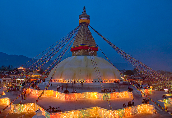
UNESCO has chosen 10 World Heritage sites, including seven ancient sites in the Kathmandu Valley, Lumbini – The Birthplace of Lord Buddha, Chitwan National Park, and Sagarmatha National Park. These heritage sites have been chosen based on their cultural and natural values. The list of Cultural World Heritage Sites: 1. Kathmandu Durbar Square In the centre of Kathmandu – Kathmandu Durbar Square, which has Hanuman Dhoka, Degutale Temple, Taleju Mandir, Nasal Chowk, Nine story Basantapur Tower, Panch Mukhi Hanuman Temple, Mul Chowk, Mohan Chowk, Sundari Chowk, Tribhuvan Museum, King Mahendra Memorial Museum, and Kal Bhairab temple in its vicinity. The Hindu Mythology claims that there would be an instant flow of milk from the wall where a single person translates the 17th-century inscription on a stone on the walls of Hanuman Dhoka. Hanuman Dhoka, the former Royal Palace of the Malla kings, passed on to the succeeding Shah dynasty. The Royal family lived in the Hanuman Dhoka palace until 1886 and shifted to The Narayanhiti Palace. However, the former is still used for ritual and ceremonial occasions. New Kings were crowned inside the palace before Nepal became a Republic. The palace has a Hanuman statue from the 17th century to the left of the palace entrance and a fantastic sculpture of Lord Narasimha. The palace bears the historical reminisce of Nepal’s Royal family, culture, and religion. The museums inside the palace let one explore the culture, religion, customs, tradition, architecture, history of Royal palaces, etc. There is an entrance fee to enter the museums. The museums remain open seven days a week except for Tuesdays, when it opens from 10.30 am to 3 pm during the winter and from 10.30 am to 4 pm in the summer. One can visit the museums on Fridays from 10.30 am to 2 pm. 2. Patan Durbar Square Patan Durbar Square lies 5 km South-East of Kathmandu Valley by Bagmati River. Four hundred fifty-nine hectares of Patan are bounded by Emperor Ashoka’s four stupas in the 3rd century B.C, as recorded in history. Patan is also called Lalitpur – City of fine arts. There are several legends attached to the origin of the term Lalitpur. One such legend says that when Kathmandu was engulfed with severe drought in ancient times, three people were assigned to summon God Red Machhendranath into the valley for rainfalls from Kamaru Kamachhya in Assam, India. Amongst the three people, one was a farmer named Lalit, who is believed to have contributed more than the other two. When rains finally poured into the valley, people, as a sign of gratitude, Sanskritized the valley after his name and the term ‘pur’, meaning township, and it was subsequently named Lalitpur. Another tale claims that the valley was named after King Yalamber. The denizens refer to Patan as Yala. History shows that Patan was founded in the 3rd century by the Kirat dynasty and later modelled into perfection by Lichhavis during the sixth century, followed by the Malla dynasty. This city presents a potpourri of the most exquisite traditional crafts and rich artistic heritage. Patan Durbar Square consists of Mahaboudha Temple, Kumbeshwor temple, Krishna Temple, Golden Temple of Hiranya Varna Mahavihar, Mulchowk, Jagat Narayan Temple, Big Bell, Pillar of Yognarendra Malla, Hari Shanker temple, Vishwanath temple, Bhimsen temple, Marga Hiti, Mani Mandap, Café Pagoda, Rato Machhendra Temple, Minnath, Rudra Varna Mahavihar. These are the major attractions of Patan. 3. Bhaktapur Durbar Square Bhaktapur lies 13 km in the Eastern part of the Kathmandu valley. It is also known as Bhadgaon or Khwopa. It is regarded as the abode of ancient Nepali culture, custom, and alluring art pieces of excellent craftsmanship. Each historical monument represents Nepal’s medieval culture, religion, and tradition. The Newari populace dominates Bhaktapur. Bhaktapur is the only place in Nepal which has remained untouched by western culture. Lion Gate, Golden Gate, Art Gallery, Statue of King Bhupatindra, Nyatapola Temple, and fifty-five windowed Malla palaces are the pride of Bhaktapur. The place has some excellent restaurants and hotels to cater to the needs and requirements of tourists. 4. Swayambhunath Stupa Swayambhunath stupa lies just 3 km westward from Kathmandu’s city centre. Ancient legend has it that it was an island a couple of thousand years ago. A stupa was built later. King Manadeva contributed to the making of the stupa in 460 AD. However, after the Mughal invasions, it was destroyed and had to undergo renovations in the 14th century. In the 17th century, King Pratap Malla further enhanced the architecture and added a stairway to the stupa. The stupa is a solid hemisphere of brick and clay, supporting a lofty conical spire capped by a copper gilt pinnacle and has Lord Buddha’s eyes painted on all four sides of the spire base. The Buddhists regard it as one of the holiest places. Swayambhunath also offers a majestic view of the entire Kathmandu valley on clear days. 5. Pashupatinath Temple Pashupatinath temple is a temple of Lord Shiva and is the holiest place shrine for Shiva. The sacred temple lies on the sacred Bagmati River banks, 5 km east of Kathmandu city. Non-Hindus are strictly prohibited from entering the temple. It has a two-tiered roof and four silver doors. However, Hindu devotees from around the world come here to pay their homage to Lord Shiva. 6. Boudhanath Stupa Boudhanath stupa epitomizes Tibetan Buddhism. It lay 8 km East of Kathmandu and was built by a Licchavi King Man Dev in the 5th century A. D. The colossal and ancient stupa is regarded as one of the world’s biggest stupa and has been built on a stepped octagonal base and inset with alcoves representing the Mandala. Tibetans came in thousands to this famous Buddhist Chaitya after the Chinese invasion of Tibet and energized the stupa. Various temples or ‘gompas’ surrounds the stupa. The whole place’s atmosphere lightens with zest as the fragrance of incense drifts through the air. Chanting monks and the creaking of prayer wheels can be heard while strolling around the stupa’s base. It is one
Top twenty highest mountains in the world
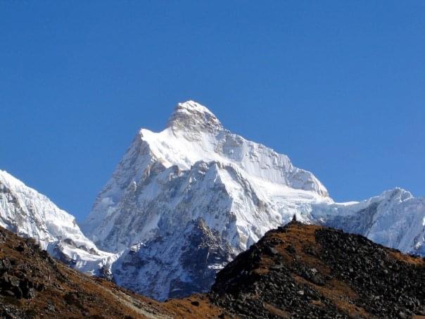
Top twenty highest mountains in the world. All 20 of the highest summits are located in central and south Asia. They are each measured as individual peaks and not as part of a mountain range. Mauna Kea, a dormant volcano that is partially submerged that is found on the island of Hawaii, is the tallest mountain in the world if measured from the Pacific Ocean floor to its summit at a staggering 10 203 meters in technicality. However, the sole objective of this list is to look at peaks whose bottom is found above sea level, i.e., both the base and top of the mountain have to be above sea level. 20. Nuptse, Mahalangur Himalaya Nuptse in Tibetan/Sherpa means’ Western peak.’ It is located in the Mahalangur range in the Khumbu region and is one of Mount Everest’s mountains. It was first ascended in 1961 by Tashi Sherpa and Dennis Davis. Nuptse is the 20th on this list of the highest mountain peaks in the world. 19. Distaghil Sar, Hispar Karakoram This peak is located in the Karakoram range of the Gilgit-Baltistan region of Pakistan. Dishtaghil Sar is almost three kilometres wide and 7884 meters in height. Gunther Starker and Diether Marchar, who were part of an Austrian expedition team, were the first to climb it in 1960. It is the highest peak of the Hispar Muztagh range. 18. Himalchuli, Manaslu Himalaya The Himalchuli peak is a part of the Nepal Himalayas and prevails south of Mount Manaslu, one of the world’s highest mountains. Himalchuli has the second-highest summit in its mountain range, i.e., Mansiri Himalaya, at 7892 meters. Hisashi Tanabe of Japan was the first person to have climbed it in 1960. 17. Gasherbrum IV, Baltoro Karakoram Gasherbrum IV is one of the peaks in the Gasherbrum mountain range, as the name suggests, and is located in Pakistan. It is at the northeast end of the Baltoro Glacier in the Karakoram range of the greater Himalayas. Gasherbrum means “Shining Wall” in the Urdu language. The rest of the three peaks in the Gasherbrum range are well above 8000 meters, while this peak is about 7932 meters in elevation. 16. Annapurna II, Annapurna Massif The Annapurna peaks are part of the Annapurna massif, forming a vital part of the Himalayan ranges. At 7934 m high, Annapurna II lies in the Annapurna range’s eastern fields, and quite contrary to the common belief in people, it is an independent peak. This peak was made by Richard Grant, Chris Bonington, and Ang Nyima Sherpa in 1960 and has seen very few ascents. 15. Gyanchung Kang, Mahalangur Himalaya Gyanchung Kang lies between the tallest mountains above 8000 meters, namely, Cho Oyu and Everest. It is part of Mahalangur Himalaya, spreading between Nepal and Tibet Autonomous Region of China. It was first climbed in 1964 by the Japanese. Gyanchung Kang marks an essential point in this list because it is the highest mountain globally, below 8000 meters. It is 7952meters in height. 14. Shishapangma, Jugal Himal We are now entering the elite mountain peaks because all the above mountains are above an altitude of more than 8000 meters. Despite being the lowest of all 8000-meter mountains, it does not necessarily make climbing any easier. It is located between Tibet and Nepal. It is in a restricted area where foreigners are not permitted to visit on security grounds. The 8013-meter high mountain Shishapangma got its name, which means “crest above the grassy meadows” in the Tibetan dialect. 13. Gasherbrum II or K4, Baltoro Karakoram Gasherbrum II lies above Gasherbrum III, and as mentioned above, it is located in the Karakoram range. The 8035-meter peak was first climbed in 1956 by an Austrian climber. Gasherbrum II is the fourth highest mountain in the Karakoram range and is known as K4. 12. Broad Peak or K3, Baltoro Karakoram The broad peak at 8051 meters is the 12th highest mountain known as Falchan Kangri. It produces some very harsh conditions around it, and climbing is nearly impossible in these ranges for most of the year. 11. Gasherbrum I or Hidden Peak or K5, Baltoro Karakoram K5 is the fifth peak of the Karakoram range and received another name in the late 20th century. The name was hidden peak due to the extreme remoteness in which it is located. Pete Schoning and Andy Kauffman, part of an eight-member American team, were the first to climb this 8080-meter peak in 1956. 10. Annapurna I, Annapurna Massif Now that we have reached the top 10, the summits’ elevation keeps getting higher, and the number of successful summits is less. Annapurna I’s main peak is the tenth tallest mountain globally, with an altitude of 8091 meters. Annapurna got its name from Sanskrit, which means “sufficient grains.” 9. Nanga Parbat, Nanga Parbat Himalayas Located in the Gilgit-Baltistan region of Pakistan, Nanga Parbat stands at 8126 meters and is locally known as Deo-mir. It is also known as “Killer Mountain” because it simultaneously has one of the highest numbers of deaths and unsuccessful expeditions; it has never been climbed during winter. The Germans gave it a term of endearment, “Unserberg,” meaning our mountain in the 1950s. 8. Manaslu, Manaslu Himal Manaslu derives from the Sanskrit word ‘Manas,’ which means ‘knowledge’ or ‘spirit.’ It lies in the Himalayas’ Gorkha district and is close to the Annapurna range. Manaslu stands at 8163 meters. A Manaslu Conservation Area Project has also been set up to maintain sustainability and conservation goals. 7. Dhaulagiri I, Dhaulagiri Himal The Dhaulagiri mountain range drains its snow across hundreds of kilometres from the Kali Gandaki river in Nepal, right into India’s Ganges. The highest of its peaks stands at 8167 meters high and is the seventh-highest peak. It is the highest point in the Kali Gandaki river valley. Dhaulagiri’s name is from the combination of two Sanskrit words – ‘Dhaula,’ which means dazzling, and Giri, meaning ‘mountain.’ 6. Cho Oyu, Mahalangur range Himalaya Cho Oyu means “Turquoise Goddess” in Tibetan. It is
Manaslu Circuit Trek Report Post Earthquake

The Manaslu circuit trekking route was severely affected by the massive earthquake of April 2015. The epicentre of that devastating earthquake was in Gorkha District, where Mount Manaslu – the world’s 8th highest mountain is located. So you must be wondering and asking the question, can I still do Manaslu Circuit trekking after the earthquake? We decided to do the trek ourselves and write a first-hand report on the trail condition. We did this trek from 4th – 17th December 2016. We were blessed with perfect weather during the trek, where the views were clear throughout. We found that most of the damage on the villages and trails were either repaired or rebuilt. In addition, the Nepal government has installed new bridges and walkways. However, in certain parts of the path where landslides occurred during the earthquake, we noticed huge boulders coming down the trail and onto the Buri Gandaki River. Road construction is going on to reach Larke La pass to connect with the Manang district. However, the construction of roads requires blasting off part of the hills, removing huge boulders, destabilising the mountain, and making it susceptible to landslides for several years. During late September, at the tail end of the monsoon, a group of trekkers and their support crew were caught in a landslide when three Nepali crew members, including the company owner, a guide, and a trekker, were killed; just a few minutes walk away from Tatopani (hot springs). This landslide had settled when we crossed it, but it could get active when it rains or the next monsoon. Landslides usually take a couple of years or more to settle ultimately. We observed a new menace was the increased number of mules plying on the trail. Despite December being off-season, the mules were used to resupply the lodges for the coming spring season. The paths are narrow, with some harrowing drops into the Buri Gandaki River. Additionally, some of the mule drivers make the mules trot while returning to the road head at Soti Khola, which can be menacing to the trekkers on the narrow trails. It is best to listen to the bells’ sounds of approaching mule caravans as a warning – so it is best not to listen to music with earphones while trekking. There are close to 2000 mules used to carry supplies to the villages along the Manaslu Circuit and Tsum Valley. We saw a new and dangerous landslide on our hike to Gap with no warning. There was a potential of falling into the raging Buri Gandaki River a couple of hundred meters below. Our porters who got to this landslide managed to get past this landslide with much difficulty. Every few steps they took forward, they slid a few steps back. Had it not been for their steady foot, there could have been some injuries or worse. While we were in Samdo, the lodge owner’s husband drives mules to supply the villages and called to inform his wife that a fresh dry landslide had cut off the trail. Unfortunately, this landslide took place close to Lapu Besi, where we had lunch on day 1 of our trek. Hence his arrival was delayed until the path was reopened. On the last day of our trek, we started from the village of Gowa. After a short walk past the village, we came upon a detour; we checked out what seemed like an alternative route to find that it went next to the raging Dudh River. We retraced our steps and passed the blocked trail to find ourselves in another landslide. Having negotiated our way across initially, we had to scramble back up to make it to a ridge we had not been able to see previously – a new road that had been constructed. It was quite a nerve-wracking experience until we reached more solid ground. There should have been a clear sign directing trekkers to the newly built road, or the lodge owners could have informed us of this matter. I hope the concerned authorities or departments will immediately rebuild the trail and signs and provide proper maintenance. Anyway, all is well that ends well. Text: Raj Tamang Photo Courtesy: Tara Austin Check out our Trekking packages for Nepal, Bhutan, India, and Tibet.