Saipal Himal Base Camp Trek
Mount Saipal is the Second Highest Peak in Far West Nepal
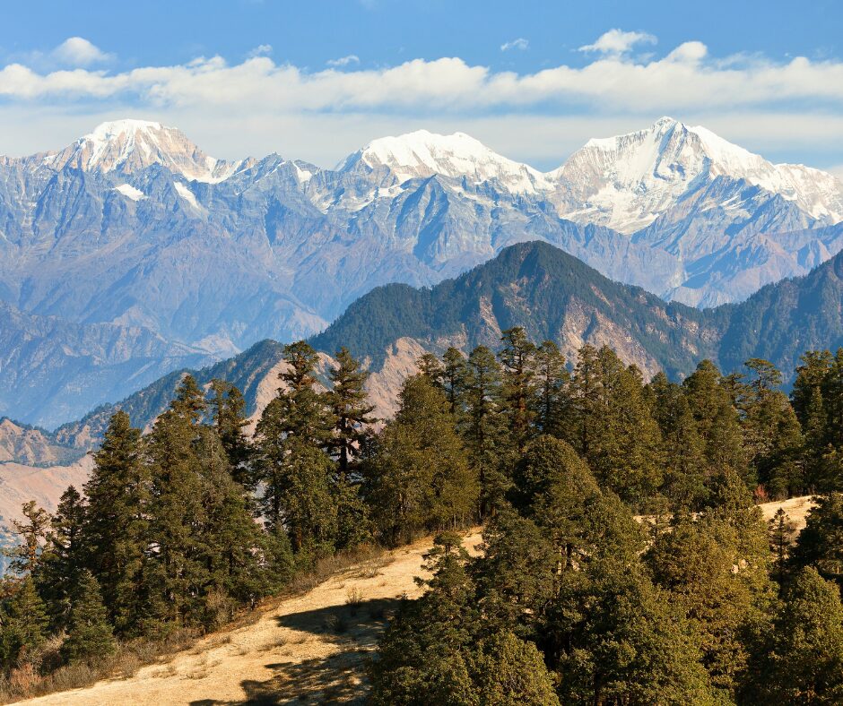
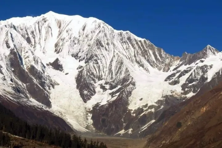
It stands at an impressive 7031 meters; it is a beautiful peak whether you view it from the east or the north. Both the East and North Saipal Base camp are accessible from Simikot. The East Base camp heads south from Simikot and makes a deviation through the steep-sided forested countryside.
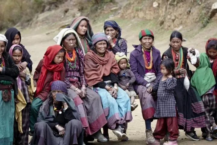
This region is culturally and geographically isolated from the rest of the nation. This region’s broad and rolling passes (lekhs) are thickly forested with enormous Deodars (Cedar-like trees), spruces and ancient blue pines. The Chhetris and Brahmins populate the villages nestling among them, and the other ethnic groups are the Thakurs and Bhotias. There is a particular cultural and economic interaction between Hindus and Buddhists unmatched elsewhere in the Himalayas.
At a glance
- Humla is one of the most fascinating places in Nepal, culturally
- It is a delightful place. Saipal Peak is every bit as stunning as the famous eight-thousand-meter mountains
- Encounter a broad range of landscapes and the Buddhist plus Hindu Cultures of this region
- It is one of the most exuberant, remote and least trekked parts of Nepal
- Simikot is also known as the Gateway to Mount Kailash in Tibet.
Mount Saipal, whose impressive height of 7031 meters, is the second-highest peak in Far West Nepal. The mountain is breathtaking whether you view it from the east or the north. Accessible from Simikot, both the East and North Saipal Base camps offer trekkers a chance to witness the majestic beauty of this peak.
To reach the East Base camp, one must head south from Simikot and traverse through the steep-sided, forested countryside. The trail takes you through a culturally and geographically isolated region from the rest of the nation. This seclusion contributes to the unique charm and allure of the area.
This region’s passes, locally known as lekhs, are broad and rolling, adorned with thick forests of enormous Deodars (Cedar-like trees), spruces, and ancient blue pines. These lush forests provide a pristine environment for various flora and fauna to thrive. Nestled among these forests are villages predominantly inhabited by the Chhetri and Brahmin communities. The Thakurs and Bhotias, belonging to other ethnic groups, also reside in this area.
One of the fascinating aspects of this region is the cultural and economic interaction between the Hindus and Buddhists, which is unique and unparalleled elsewhere in the Himalayas. This harmonious coexistence between different religious and cultural practices contributes to the diversity and richness of the region.
As you trek through the remote trails towards Mount Saipal, you can expect to witness the grandeur of the mountain, the natural beauty, secluded villages, and the fascinating blend of Hindu and Buddhist traditions. These combined elements make the journey truly memorable and provide an opportunity to immerse oneself in the distinctive atmosphere of Far West Nepal.
Itinerary
Upon arriving in Kathmandu, your trek leader will greet you at the airport and accompany you to your hotel. They will then provide a detailed briefing on the program for the next few days. This briefing will cover essential information such as the trek itinerary, logistics, accommodations, permits, safety precautions, and any specific highlights or challenges you may encounter. It will also allow you to ask questions and gain a clear understanding of what to expect during the trek. By receiving this comprehensive briefing, you will be well-prepared and equipped for the upcoming adventure.
In the morning, you will take a sightseeing tour of Patan Durbar Square, a UNESCO World Heritage site known for its ancient architectural wonders. Patan Durbar Square is a cultural hub that showcases intricate pagodas, temples, and palaces, reflecting the rich history and artistic heritage of the Kathmandu Valley.
After exploring Patan Durbar Square, you will visit Kirtipur, a quaint town southwest of Kathmandu. Kirtipur offers a fascinating glimpse into Newar culture and architecture. With its narrow streets, old houses, and temples, Kirtipur exudes a traditional charm that transports visitors back in time.
For lunch, you will have the opportunity to savour Newari cuisine at Lahana Restaurant. Newari food is renowned for its distinct flavours and unique culinary traditions. Lahana Restaurant provides an authentic experience, serving a variety of “finger food” dishes comparable to tapas. This allows you to sample a range of delectable Newari delicacies delightfully and interactively.
Later in the day, you will be driven to the domestic airport for a 55-minute flight to Nepalgunj. Nepalgunj is located in the western part of Nepal and serves as a major transit hub for treks in the remote western regions.
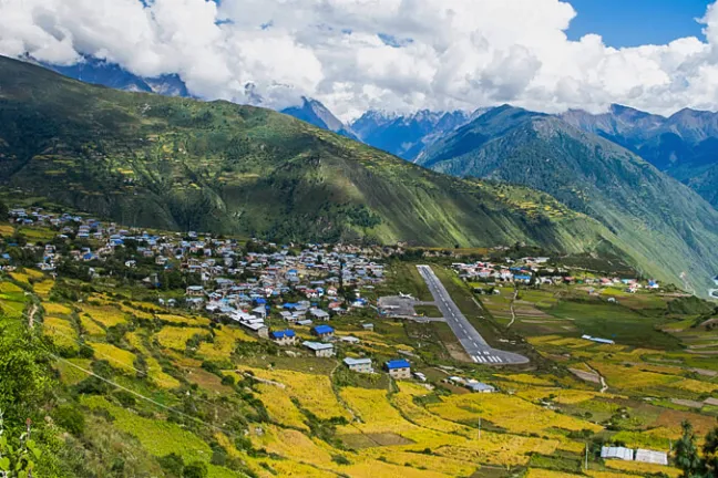
Upon arrival in Nepalgunj, you will stay overnight to catch an early morning flight to Simikot, the gateway to the Humla district. Simikot is a picturesque town situated in the mountains of northwestern Nepal. This flight will take you closer to the starting point of your trek, allowing you to immerse yourself in the natural beauty and cultural richness of the Humla district.
This day offers a combination of cultural exploration, culinary delights, and travel arrangements, setting the stage for the adventure ahead in the Humla district’s stunning landscapes.
You will take a scenic 45-minute flight from Nepalgunj to Simikot in the morning. As the plane ascends, you can admire picturesque views of the plains and navigate through the Siwalik Range. Keep your eyes peeled, as you may even catch glimpses of majestic mountains such as East Dhaulagiri and Churen Himal if weather permits. The flight itself is an exhilarating experience, providing a thrilling perspective of the landscape below.
Simikot, being the district headquarters of Humla, is a bustling town equipped with commercial banks, government and non-government offices, and educational institutions. The local population practices Buddhism and Hinduism, creating a unique cultural blend. The climate in Simikot is moderately warm and temperate, with notable rainfall during summers and occasional snowfall in winters. The average annual temperature in Simikot is 10.1 °C, with an average yearly rainfall of approximately 783 mm.
Upon arrival in Simikot, you will retrieve your luggage and load it onto pack animals, ready to commence your trek. The first destination for the day is Bargaun village, which will be your overnight stop. Descending through steep-sided valleys, you will encounter various highlights along the way. One of the notable highlights is the shrine at Karpunath, adding a cultural and spiritual dimension to your trekking experience.
Bargaun village is located in the Khapunath Gaupalika area, particularly in Yangshuo, which rests on the banks of the Karnali River at the base of the Bigauda Danda range. The village primarily consists of Thakuris, a predominantly Hindu population, and a small Dalit community. The natural beauty and cultural richness of Bargaun village make it an ideal place to set up camp and spend the night, immersing yourself in the serene surroundings.
As you settle into your camp in Bargaun village, you can look forward to a restful evening, surrounded by the tranquillity of nature and the warm hospitality of the local community.
After enjoying a memorable homestay experience in Bargaun village, your journey continues as you descend towards the Karnali River. Following the trail once used by sheep caravans, you will trace the path leading to the Karnali Valley, with your next destination being Lali village.
The trail meanders through remote and untouched areas of the Humla Karnali region, offering a unique and off-the-beaten-path experience. As you traverse this sacred loop, you will be immersed in the pristine beauty of the natural surroundings and have the opportunity to witness the unspoiled landscapes that define this region.
The day’s trek will take you through diverse terrain, allowing you to enjoy the changing vistas and immerse yourself in the tranquillity of nature. As you descend towards the Karnali River, you will be treated to breathtaking views and a sense of adventure from exploring remote and less frequented areas.
In the evening, you will set up camp, allowing you to unwind and immerse yourself in the peaceful ambience of your surroundings. Camping amidst the beauty of nature will offer a chance to rejuvenate, reflect on your experiences, and prepare for the adventures ahead.
Overnight, you will be sleeping under the starry skies, surrounded by the serene landscapes of the Humla Karnali region, creating lasting memories of this remarkable journey.
The morning after your peaceful camping experience, you can look forward to a rejuvenating start with hot cups of fresh coffee or tea. This will awaken your senses and prepare you for another day of adventure. As you enjoy your beverage riverside, listening to the soothing sounds of the roaring river, you will feel invigorated and ready for the day’s hike.
Setting off from camp, you will begin hiking on the Humla Karnali River valley trail, taking the fast track. The trail will lead you through diverse landscapes, including a forest abundant with alder, oak, walnuts, Himalayan bamboo, juniper, and pine trees. The lush greenery and varied flora will enhance your trekking experience, providing shade and a serene atmosphere as you go southwards.
After a while, you will reach Bokche Gauda, where a tea house is located. This will be a perfect spot to rest, replenish your energy, and enjoy some refreshments before continuing your journey. It provides a brief interlude where you can relax and appreciate the hospitality of the tea house.
As you resume your trek, you will continue southward, closely following the river’s course. This route will lead you to the Bluff of Lali, an elevated area where lunch will be served. With its panoramic views, this scenic location will provide a perfect setting to rest and refuel before carrying on with your trek.
The trail from Lali Bluff onwards will be undulating, with gentle ups and downs. The path will lead you through Biubare, where the valley starts to widen, and a forest of tall pine trees will surround you. Seeing these majestic trees will create a serene and enchanting atmosphere, adding to the beauty of your surroundings.
Finally, you will reach Rip Ghat, where you will stop for the night. Here, amid nature’s tranquillity, you will set up camp and spend a peaceful evening. The soothing ambience of Rip Ghat and the company of fellow trekkers will allow you to unwind, reflect on the day’s journey, and prepare for the adventures yet to come.
Overnight, you will once again find yourself immersed in the beauty of nature, sleeping under the starlit sky, surrounded by the calming sounds of the river and the forest.
As you continue your trek, today’s trail presents a higher challenge as you turn westward. The path winds through pristine forests, revealing a remarkable landscape that has remained largely untouched and seldom visited by outsiders. The few small settlements scattered along the route have maintained their seclusion, preserving their unique culture and way of life.
Leaving the Humla Karnali River behind as it veers to the southeast, you will now follow a smaller river towards the picturesque Kheta Khola Valley. This valley offers a breathtaking display of natural beauty, with its meandering river and surrounding hills creating a serene atmosphere.
Navigating the trail will take you around the valleys, eventually leading you to Ogaliya. This small settlement is rarely visited by travellers, adding to the sense of remoteness and exploration. You will continue your journey from here, traversing the spurs and undulating terrain until you reach Bhuagdiya.
Bhuagdiya is a potential campsite for the night, providing a flat and spacious location near the Khet Khola. Nestled amidst the tranquillity of nature, you will rest and set up camp in this idyllic setting. Surrounded by the peacefulness of the valley and the sounds of the river, you will have an opportunity to relax, rejuvenate, and reflect on the challenges and rewards of the day’s trek.
Overnight, your campsite will be a sanctuary within the beauty of the Kheta Khola Valley. As you bask in the calmness of the surroundings and admire the starry sky above, you will appreciate the remoteness of your location and the unique experiences gained throughout this remarkable journey.
On this challenging day of your trek, you will find yourself immersed in a dense pine forest with towering trees providing shading and a mystical atmosphere. The snow-clad peaks, unfortunately, remain out of sight as the trail leads you deep into the valleys.
Your hike will take you towards the Dhid Lagna Pass, and the journey to reach this destination involves a steep ascent. The trail winds up the rugged terrain from the Khet Khola, gradually gaining elevation. As you face the physical demands of the steep climb, your determination and endurance will be tested. The Dhid Lagna Pass, which lies at an estimated altitude of 3650 meters, marks a significant milestone in your trekking adventure.
Once you reach the pinnacle of the pass, you will be rewarded with breathtaking panoramic views, even if the snow-clad peaks remain hidden from your sight. Take a moment to absorb the awe-inspiring surroundings fully and appreciate the accomplishment of conquering the steep ascent.
The descent from the Dhid Lagna Pass is equally challenging as the trail descends sharply towards the Kawadi Khola. Be prepared for a steep, demanding downhill stretch requiring concentration and careful footwork.
Continuing along the trail, you will follow the valley towards the northwest, observing the ever-changing scenery. The path leads you to Lampate, where you will set up camp for the night. Surrounded by the serene beauty of the valley and the tranquillity of nature, you will find solace in your overnight camp, reflecting on the challenges you’ve overcome and relishing in the rewards of your journey.
Overnight, you will be embraced by the serenity of Lampate, allowing you to rest and rejuvenate in preparation for the exciting adventures on your trekking expedition.
As you embark on another day of trekking, the trail gradually leads you away from the pine forest below, revealing open pastures and a wider expanse of landscape. The ascent up the hillside will offer you a change in scenery, with the lush greenery of the pastures replacing the dense forest.
The distance to Rani Kharka, your next destination, might pose a challenge depending on the distance covered from the campsite at Lampate the previous night. It is essential to gauge your energy levels and pace yourself accordingly. The trail will guide you further along the valley as you continue your journey.
As you progress, prepare to be rewarded with breathtaking panoramic views that unfold before your eyes. The route leads you to Dhaule Kharka, where nature’s beauty is fully displayed. Take a moment to soak in the awe-inspiring surroundings and appreciate the vastness of the landscape.
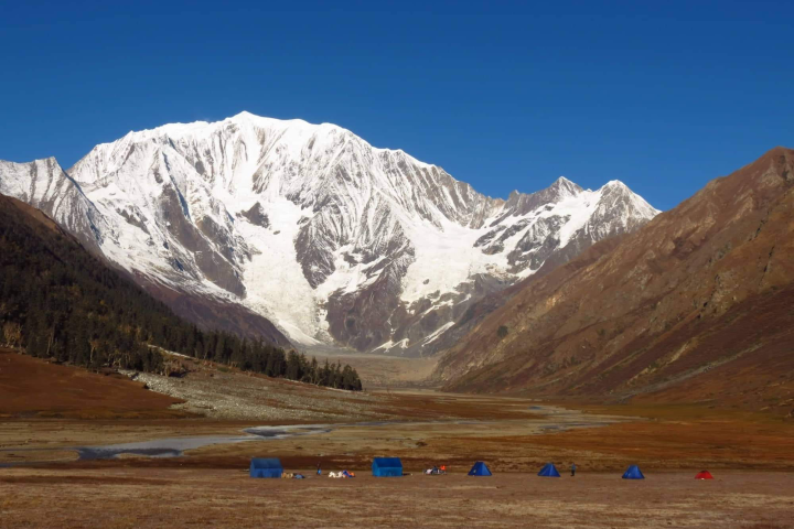
The campsite for the night is usually set up at Rani Kharka. Here, you will be treated to a magnificent view of the massive East face of Mount Saipal. The sight of this majestic mountain, towering above the surrounding terrain, will leave a lasting impression and serve as a reminder of the sheer grandeur of nature.
Settle into your campsite at Rani Kharka and let the magnificence of the surroundings sink in. You will spend the night under the starry sky, enjoying the tranquillity and peacefulness of this remarkable location. Take the time to reflect on the incredible experiences of your journey so far and savour the beauty surrounding you in this unique and special place.
Overnight, you will be immersed in the enchanting ambience of Rani Kharka, allowing you to rest, appreciate the wonders of nature, and gather your strength for the adventures that lie ahead on your trek.
As you continue your trek towards the base camp, the duration of the day can be adjusted based on the physical condition and preferences of the trekkers. Since the journey to the base camp and back follows the same trail, you have flexibility in determining the length of your trek. The primary goal is to get as close as possible to the massive East face of Saipal, which serves as a prominent landmark in the region.
The Nunekhara Glacier snout marks the furthest point one can reach without climbing gear. As you approach this point, you will admire the awe-inspiring sight of the glacier, showcasing its grandeur and power. This will be a highlight of your trekking adventure as you come face to face with the magnificence of nature.
Throughout your trek, you will be surrounded by a diverse and majestic flora.
Pines, juniper trees, vibrant Himalayan rhododendrons, and a variety of Himalayan herbal bushes will grace your path, enhancing the region’s scenic beauty. Combining these vegetation types creates a picturesque backdrop against which your trek unfolds.
Additionally, the region is known for its rich birdlife. Watch for the beautiful Himalayan Monals, majestic eagles, and soaring vultures. These captivating winged creatures are regular inhabitants of this area and provide a glimpse into the fascinating ecosystem of the Himalayas.
As the day ends, you will set up camp for the night. This is an opportunity to immerse yourself in the tranquillity of the surroundings, listening to the serene sounds of nature and appreciating the region’s untouched beauty. The overnight camp will offer you moments of reflection and relaxation, allowing you to recharge for the next leg of your expedition.
Take in the magnificent views and memorable experiences of the day, and let the serenity of the campsite embrace you as you prepare for a restful night nestled amidst the wonders of the Himalayas.
Considering the challenges of crossing the Sakya Lagna and the distance to the camp on the north side, it is understandable that many trekkers may choose not to attempt it on this particular day. Instead, a leisurely day can be planned, allowing for more time to explore and enjoy the valley’s scenic beauty before bidding farewell to Rani Kharka.
Setting off from Rani Kharka, the trail leads you through Tharang Kharka, a simple shelter providing a brief resting point. Here, you can take a moment to recharge and catch your breath before continuing on your journey.
Heading north into the Lepcha Khola, the trail ascends, taking you higher into the mountains. As you steadily climb, you will pass through diverse landscapes and witness the impressive natural features of the region. The aim is to reach a campsite near or at Lepcha Kharka, approximately 4450 meters.
The campsite at or near Lepcha Kharka offers a unique opportunity to immerse yourself in the rugged beauty of the Himalayas. From this vantage point, you can marvel at the stunning views surrounding you and appreciate the raw grandeur of this mountainous region.
As night falls, settle into the camp and allow yourself to be captivated by the peacefulness of the surroundings. You will have the chance to reflect on your journey thus far and relish the sense of accomplishment that comes from immersing yourself in the wilderness and overcoming the challenges of the trail.
Ensure that you take the time to rest and replenish your energy for the adventures that await you in the days ahead. The campsite provides a haven where you can recharge your body and mind, preparing yourself for the next stage of your trekking expedition.
The ascent to Sakya Lagna, standing at an elevation of 4709 meters, is challenging and arduous. However, the effort becomes worthwhile when you reach the top and are rewarded with breathtaking panoramic views. From this vantage point, you can marvel at the magnificent sight of Saipal, radiating its brilliance towards the southwest. Looking north, you will witness the formidable and awe-inspiring jagged ridges that mark the boundary of the Tibetan plateaus. These views serve as a reminder of the raw and untamed beauty of the Himalayas.
As you descend from Sakya Lagna, the trail leads you through Khaniphuk Kharka, where you will navigate steep terrain until you reach the confluence of the Karang Khola and Kalungba Khola. This section of the journey allows you to immerse yourself in the abundant flora and fauna that grace the region. The Himalayan flora, with its rich diversity of plant life and the captivating fauna, including various species of wildlife, add to the charm and allure of the area.
The trail takes a westward direction from the confluence, following a path north of the Saipal Base Camp. The next significant destination along the route is Chala, situated at an elevation of 3750 meters. Chala is a traditional Tibetan settlement where it may be necessary to engage the services of a local guide and utilize local mules for transportation. Planning and coordinating this journey aspect is essential to ensure a smooth experience.
While Chala presents logistical challenges, it is also an opportunity to experience the unique culture and way of life in a traditional Tibetan settlement. Take the time to appreciate the local customs, interact with the residents, and gain insights into their rich cultural heritage.
Following a long day of trekking, you will set up camp at your overnight location. This peaceful and serene setting amid the wilderness offers a chance to reflect on the day’s adventures, savour the sights and sounds of the surroundings, and prepare for the next leg of your journey.
Ensure you take the time to rest and rejuvenate at the campsite, allowing your body and mind to recover from the physical demands of the trek. This will enable you to approach the subsequent days with renewed energy and enthusiasm, ready to explore further and create lasting memories amidst the enchanting landscapes of the Himalayas.
Today’s journey takes us through the highest pass of this trip, Sakya Lagna, which stands at approximately 4709 meters. The ascent to the pass may be physically demanding, but the extraordinary panoramic views at the top make all the effort worthwhile. Gazing towards the southwest, we will be greeted by the radiant presence of Saipal, adding a touch of brilliance to the scenery. To the north, we will be treated to the sight of the formidable and seemingly endless jagged ridges that define the edge of the Tibetan plateaus. The contrast between these majestic landscapes exemplifies the raw beauty of the region.
Descending from Sakya Lagna, our path leads us steeply through Khaniphuk Kharka until we reach the confluence of the Kerang Khola and Kalungba Khola. This section of the journey offers an opportunity to take in the diverse flora and fauna that thrive in this Himalayan region. The wide range of plant life and the possibility of encountering wildlife enhance the allure of the surroundings.
Upon reaching the confluence, we will find trails that depart westward, leading to the north side of Saipal Base Camp. Crossing the Khalungba River, we will then begin our ascent towards Chala. Situated at approximately X meters, Chala is a traditional Tibetan village that showcases a distinct way of life and cultural heritage. It may prove beneficial to have a knowledgeable guide to navigate and appreciate the nuances of this unique settlement.
Our overnight stay will be at a campsite, where we can revel in the serenity of the surroundings and reflect on the day’s endeavours. This tranquil setting allows us to recharge our bodies and minds, preparing us for the adventures. Take this opportunity to rest, immerse yourself in nature, and appreciate the majesty of the Himalayas.
By embracing each stage of our journey, we can fully savour the experiences, overcome the challenges, and create lasting memories of this extraordinary trek.
The journey from Chala presents a significant challenge as we approach Yalbang. The trail takes us across the Syakup Pass, standing at an elevation of 4214 meters, which acts as an obstacle along the route. Overcoming this hurdle requires perseverance and determination.
Once we conquer the pass, the trail descends steeply into the side valley of Puiya Khola. Here, we enter a forested area where a trail carved through the trees leads us to the Humla Karnali Bridge near Muchu. The descent into the valley allows us to immerse ourselves in the natural beauty of the surroundings.
From the bridge, we begin a steady climb towards Yalbang. The village of Yalbang is home to a monastery where monks reside and study Buddhism, including informal education in subjects such as Mathematics and the English language. This spiritual centre adds a cultural dimension to the journey, allowing us to observe the practice and teachings of Buddhism in this remote and serene setting.
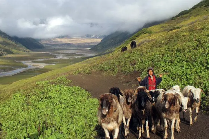
It is worth noting that the trail we are following holds historical significance as it served as an ancient trade route for the transportation of salt between Nepal and Tibet. This path was once frequented by caravans of sheep and goats, highlighting the economic and cultural exchanges between these regions.
As we continue our trek, we can revel in the rich biodiversity along the trail. The region boasts various Himalayan flora and fauna, providing ample opportunities for nature enthusiasts to observe and appreciate the natural beauty surrounding us.
Once again, our overnight stay will be at a campsite, allowing us to find solace in the tranquillity of the wilderness and reflect upon the day’s adventures. This immersive experience amid nature offers a chance to disconnect from the outside world and find peace in the simplicity of the journey.
Remember to take the time to rest and recharge for the days ahead. By embracing the challenges and immersing ourselves in this region’s unique cultural and natural offerings, we continue to create unforgettable memories in this remarkable corner of the world.
As we leave Yalbang, the trail takes us on a descent towards Yalbang Chaur. After reaching Yalbang Chaur, we begin our ascent, navigating the cliffs and winding through the narrow Karnali canyon. This section of the trail offers a thrilling and scenic experience as we traverse the rugged terrain.
Continuing our journey, we arrive at the picturesque Salli Khola Valley. Here, we are greeted with breathtaking views as we make our way through the valley. After a short climb, the trail leads us to Salli Lagna, offering an opportunity to appreciate the surrounding natural beauty.
From Salli Lagna, we follow an eastward road trail that gently contours its way down and around to Kermi. Along this section, the trail is adorned with the majestic Blue Pine trees dominating the landscape. Additionally, we encounter other varieties of trees, such as Alnus and willow, contributing to the rich diversity of the Himalayan flora.
As we immerse ourselves in the natural surroundings, we can encounter diverse Himalayan fauna. One notable bird species often spotted in this region is the Himalayan Monal, easily recognizable by its vibrant plumage.
Upon reaching Kermi, we can indulge in the local hot springs if time permits. The soothing waters of the hot springs provide a relaxing and rejuvenating experience, allowing us to unwind and soak in the therapeutic benefits.
Once again, our overnight stay will be at a campsite, allowing us to connect with nature and revel in the tranquillity of the surroundings. As the day comes to a close, take the opportunity to reflect on the remarkable landscapes, the unique flora and fauna, and the experiences shared on this incredible journey through the heart of the Himalayas.
Remember to take care of yourself, stay hydrated, and make the most of the opportunity to immerse yourself in the natural wonders surrounding you.
Kermi, a charming and sizeable Himalayan village, welcomes us with its unique cultural heritage. The residents of Kermi are predominantly of Tibetan origin, practising Buddhism as their spiritual path and speaking their dialect. This provides us a valuable opportunity to immerse ourselves in their traditions and gain insights into their way of life.
Leaving Kermi, the trail now follows the main route that connects the Tibetan border to Simikot, running alongside the Karnali River and its scenic valley. This leg of the journey is relatively easy, presenting fewer challenges than previous sections. The gentle terrain allows us to appreciate the natural beauty and serenity of the surroundings while progressing steadily.
If it fits within our itinerary, passing through Dharapori along the way is advisable. Dharapori is a community composed of Thakuris, the majority, and a small minority of Dalits, belonging to the untouchable caste and following the Hindu religion. Visiting Dharapori provides an opportunity to witness the region’s diverse religious and cultural mosaic, expanding our understanding of the local communities and their coexistence.
Throughout this journey, we are fortunate to be surrounded by abundant plant life. The area is characterized by blue pines, junipers, alder trees (Alnus), and various apricot trees. The diverse flora adds to the scenic beauty, creating a tapestry of colours and fragrances that enhance the trekking experience.
Once again, our overnight accommodation will be in a campsite, allowing us to fully immerse ourselves in the natural surroundings and enjoy a peaceful night’s rest. Take the time to absorb the tranquillity, reflecting on the cultural encounters and natural wonders that have unfolded along this remarkable trail through the remote Himalayan region.
As we move forward, let us continue to appreciate the unique blend of nature, culture, and spirituality this journey offers, creating lasting memories and deepening our connection to this awe-inspiring part of the world.
Continuing our trek, we pass through Majgaun, a small village primarily inhabited by the Thakuri community. Thakuris follow the Hindu religion and mainly speak Nepali. This village provides us with another glimpse into the region’s cultural diversity, allowing us to appreciate the different traditions and ways of life within the Himalayas.
As we proceed towards our final destination, Simikot Lagna, the trail becomes more challenging, but it is a fitting finale to our trek. The slight frustration experienced during this last stretch enhances the sense of accomplishment as we approach the end of our journey. A short descent on a stony path leads us back to the comforts and luxuries of Simikot.
Throughout this final leg, the trail meanders through a landscape dominated by blue pine trees. The community has actively conserved the surrounding forests, resulting in the presence of juniper and pipal trees as well. Combining these different tree species creates a harmonious environment permeated by the pleasing aroma of pine that lingers in the air.
Upon reaching Simikot Lagna, we are rewarded with a magnificent view of Simikot’s settlement from the summit. This panoramic vista serves as a reminder of the vastness and beauty of the Himalayan region, leaving a lasting impression as we bring our trek to a close.
We will have the opportunity to rest in a guest house in Simikot for our overnight stay. The comfort and amenities of the guest house offer a well-deserved rest after our adventurous journey, allowing us to reflect on the incredible experiences, cultural encounters, and natural wonders we have witnessed along the way.
As we prepare to bid farewell to the trekking route, let us cherish the memories created, the lessons learned, and the connections made with the people and landscapes of this remarkable region. The journey may end, but the experiences and impressions gained will endure, shaping our understanding and appreciation of the Himalayas for years to come.
Simikot is the district headquarters and a vibrant hub where various communities converge. In addition to the local Humli people, you can also find individuals from different parts of Nepal residing and working in Simikot. This amalgamation of diverse backgrounds and cultures creates a dynamic environment where one can observe a blend of cultural, traditional, and religious customs.
We embark on the first flight from Simikot to Nepalgunj to conclude our expedition. Ideally, this flight is scheduled in good weather conditions to ensure a smooth journey. From Nepalgunj, we then connect to a flight to Kathmandu on the same day, allowing us to reach the capital city by afternoon.
Once in Kathmandu, we check into a hotel where we will spend the night. The hotel offers a comfortable and convenient stay, providing a well-deserved rest. After the exhilarating journey through the remote reaches of the Himalayas and the cultural encounters we have experienced, the hotel in Kathmandu becomes a haven of relaxation and reflection.
As we settle into the hotel, we can take this time to unwind, reminisce about the incredible trek we have completed, and appreciate the diverse landscapes and communities we encountered. With its rich history and cultural significance, Kathmandu serves as a fitting place to conclude our adventure and further explore the wonders of Nepal.
In the following days, we can seize the opportunity to explore the cultural attractions, historical sites, and vibrant markets that Kathmandu offers. This will allow us to delve deeper into the cultural richness of Nepal and savour the unique experiences this extraordinary country has in store.
Let us embrace the comfort of the hotel, relish in the accomplishments of our journey, and take the time to recharge before continuing to immerse ourselves in the vibrant tapestry of life that awaits in Kathmandu.
Time for farewells. We hope you enjoyed the time in Nepal with us.
Inclusions
- Boutique hotel in Kathmandu with breakfast
- Mentioned sightseeing.
- Private vehicle
- Domestic flights
- 3-men tent (for two trekkers) for the trekking part
- Expert trek leader or hire Raj
- Trekking chef
- One assistant guide per 4 trekkers
- Chef’s assistants
- Porters to carry all camping gear, food, and equipment
- All meals on the trek – the best and healthiest food in the Himalayas.
- Toilet tent.
Exclusions
- International airport taxes
- Visas
- All optional additional tours or activities during free time
- Transportation outside of the tour program
- Travel insurance (compulsory to have insurance that covers helicopter evacuation)
- Tips (suggested amount US$100 per week for staff only); Leader’s tips at your discretion
- Items of a personal nature, e.g., alcoholic drinks, bottled beverages, laundry, souvenirs, etc.